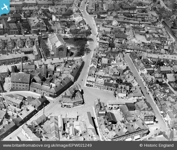
EPW021249 ENGLAND (1928). Old Market Plain and St Peter's Church, Lowestoft, 1928
© Copyright OpenStreetMap contributors and licensed by the OpenStreetMap Foundation. 2024. Cartography is licensed as CC BY-SA.
Nearby Images (8)
Details
| Title | [EPW021249] Old Market Plain and St Peter's Church, Lowestoft, 1928 |
| Reference | EPW021249 |
| Date | May-1928 |
| Link | |
| Place name | LOWESTOFT |
| Parish | |
| District | |
| Country | ENGLAND |
| Easting / Northing | 654999, 293666 |
| Longitude / Latitude | 1.7558685498389, 52.480850213819 |
| National Grid Reference | TM550937 |
Pins
 Harvey |
Saturday 1st of July 2023 02:27:04 PM | |
 Harvey |
Saturday 1st of July 2023 02:09:00 PM | |
 Eddy |
Friday 10th of September 2021 04:41:25 PM | |
 Eddy |
Wednesday 11th of August 2021 02:03:01 PM | |
 Eddy |
Thursday 20th of August 2020 03:02:42 PM | |
 Eddy |
Wednesday 19th of August 2020 02:52:41 PM |


![[EPW021249] Old Market Plain and St Peter's Church, Lowestoft, 1928](http://britainfromabove.org.uk/sites/all/libraries/aerofilms-images/public/100x100/EPW/021/EPW021249.jpg)
![[EAW047604] Rant Score and environs, Lowestoft, 1952](http://britainfromabove.org.uk/sites/all/libraries/aerofilms-images/public/100x100/EAW/047/EAW047604.jpg)
![[EAW047606] Rant Score and environs, Lowestoft, 1952. This image was marked by Aerofilms Ltd for photo editing.](http://britainfromabove.org.uk/sites/all/libraries/aerofilms-images/public/100x100/EAW/047/EAW047606.jpg)
![[EAW047602] Rant Score and environs, Lowestoft, 1952. This image was marked by Aerofilms Ltd for photo editing.](http://britainfromabove.org.uk/sites/all/libraries/aerofilms-images/public/100x100/EAW/047/EAW047602.jpg)
![[EAW047603] Rant Score and environs, Lowestoft, 1952. This image was marked by Aerofilms Ltd for photo editing.](http://britainfromabove.org.uk/sites/all/libraries/aerofilms-images/public/100x100/EAW/047/EAW047603.jpg)
![[EAW047607] Rant Score and environs, Lowestoft, 1952. This image was marked by Aerofilms Ltd for photo editing.](http://britainfromabove.org.uk/sites/all/libraries/aerofilms-images/public/100x100/EAW/047/EAW047607.jpg)
![[EAW047600] Rant Score and environs, Lowestoft, 1952. This image was marked by Aerofilms Ltd for photo editing.](http://britainfromabove.org.uk/sites/all/libraries/aerofilms-images/public/100x100/EAW/047/EAW047600.jpg)
![[EAW047599] Whapload Road and environs, Lowestoft, 1952. This image was marked by Aerofilms Ltd for photo editing.](http://britainfromabove.org.uk/sites/all/libraries/aerofilms-images/public/100x100/EAW/047/EAW047599.jpg)
