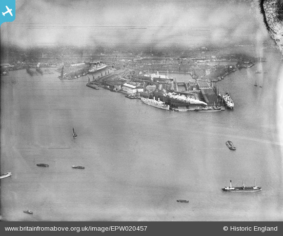
EPW020457 ENGLAND (1928). The Docks, Southampton, from the south, 1928
© Copyright OpenStreetMap contributors and licensed by the OpenStreetMap Foundation. 2024. Cartography is licensed as CC BY-SA.
Nearby Images (8)
Details
| Title | [EPW020457] The Docks, Southampton, from the south, 1928 |
| Reference | EPW020457 |
| Date | 16-March-1928 |
| Link | |
| Place name | SOUTHAMPTON |
| Parish | |
| District | |
| Country | ENGLAND |
| Easting / Northing | 442521, 109321 |
| Longitude / Latitude | -1.3955065385745, 50.881259900261 |
| National Grid Reference | SU425093 |
Pins
Be the first to add a comment to this image!


![[EPW020457] The Docks, Southampton, from the south, 1928](http://britainfromabove.org.uk/sites/all/libraries/aerofilms-images/public/100x100/EPW/020/EPW020457.jpg)
![[EPW041068] The docks, Southampton, from the south, 1933](http://britainfromabove.org.uk/sites/all/libraries/aerofilms-images/public/100x100/EPW/041/EPW041068.jpg)
![[EAW008807] The docks, Southampton, from the south, 1947](http://britainfromabove.org.uk/sites/all/libraries/aerofilms-images/public/100x100/EAW/008/EAW008807.jpg)
![[EPW039726] The Docks, Southampton, from the south, 1932](http://britainfromabove.org.uk/sites/all/libraries/aerofilms-images/public/100x100/EPW/039/EPW039726.jpg)
![[EAW033408] The Docks, Southampton, from the south, 1950](http://britainfromabove.org.uk/sites/all/libraries/aerofilms-images/public/100x100/EAW/033/EAW033408.jpg)
![[EAW035243] The docks and the city, Southampton, from the south, 1951](http://britainfromabove.org.uk/sites/all/libraries/aerofilms-images/public/100x100/EAW/035/EAW035243.jpg)
![[EPW037410] Boats in the Southampton Water, Southampton, from the north-west, 1932. This image has been produced from a damaged negative.](http://britainfromabove.org.uk/sites/all/libraries/aerofilms-images/public/100x100/EPW/037/EPW037410.jpg)
![[EAW051596] Southampton Docks, Southampton, from the south, 1953](http://britainfromabove.org.uk/sites/all/libraries/aerofilms-images/public/100x100/EAW/051/EAW051596.jpg)