
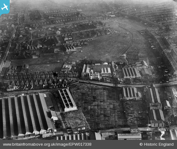
EPW017338 ENGLAND (1926). Baird & Tatlock's Scientific Instrument Factory and environs, Walthamstow, 1926
© Copyright OpenStreetMap contributors and licensed by the OpenStreetMap Foundation. 2024. Cartography is licensed as CC BY-SA.
Nearby Images (36)
EPW017338

EPW017344

EPW017337

EPW017340

EPW017341

EPW017339

EPW037541

EAW025748

EPW037544

EAW035357

EAW035350

EAW035351

EAW035349

EPW037545

EAW035353

EPW037543

EPW037919

EPW037546

EPW037540

EPW037922

EAW035352

EAW035355

EAW035359

EPW037547

EPW037921

EPW037918

EPW037920

EPW037542

EAW025752

EAW035358

EAW035356

EAW025753

EPW037925

EAW025749

EPW037926

EAW025751

Details
| Title | [EPW017338] Baird & Tatlock's Scientific Instrument Factory and environs, Walthamstow, 1926 |
| Reference | EPW017338 |
| Date | 8-December-1926 |
| Link | |
| Place name | WALTHAMSTOW |
| Parish | |
| District | |
| Country | ENGLAND |
| Easting / Northing | 535903, 189875 |
| Longitude / Latitude | -0.037924914440072, 51.5908394878 |
| National Grid Reference | TQ359899 |
Pins
 DuncanHolmes |
Thursday 28th of June 2012 09:51:39 AM |
User Comment Contributions
High Maynard reservoir in the foreground, Blackhorse Lane winding across the middle of the photo. The area is still an industrial estate. Although most of the buildings are now tin sheds some older buildings survive, including one of the factory chimneys (next to the word WORKS painted on a roof). Barbican Arts Trust studios now occupy the white building with a distinctive twin sawtooth roof, but the large house in front of it (with a semicircular bay window) is now a petrol station. |
DuncanHolmes |
Thursday 28th of June 2012 10:02:41 AM |