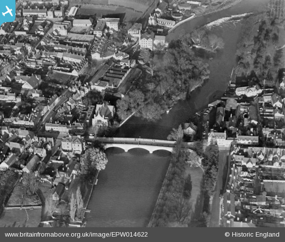
EPW014622 ENGLAND (1925). Bengeworth Bridge, Evesham, 1925. This image has been produced from a copy-negative.
© Copyright OpenStreetMap contributors and licensed by the OpenStreetMap Foundation. 2024. Cartography is licensed as CC BY-SA.
Nearby Images (19)
Details
| Title | [EPW014622] Bengeworth Bridge, Evesham, 1925. This image has been produced from a copy-negative. |
| Reference | EPW014622 |
| Date | 10-December-1925 |
| Link | |
| Place name | EVESHAM |
| Parish | EVESHAM |
| District | |
| Country | ENGLAND |
| Easting / Northing | 404022, 243734 |
| Longitude / Latitude | -1.9412879860347, 52.091523001574 |
| National Grid Reference | SP040437 |
Pins
Be the first to add a comment to this image!


![[EPW014622] Bengeworth Bridge, Evesham, 1925. This image has been produced from a copy-negative.](http://britainfromabove.org.uk/sites/all/libraries/aerofilms-images/public/100x100/EPW/014/EPW014622.jpg)
![[EPW023906] Bengeworth Bridge and Bridge Street, Evesham, 1928](http://britainfromabove.org.uk/sites/all/libraries/aerofilms-images/public/100x100/EPW/023/EPW023906.jpg)
![[EAW039994] Swan Lane First School alongside the Willmotts Ltd Factory and Workman Bridge, Evesham, 1951. This image was marked by Aerofilms Ltd for photo editing.](http://britainfromabove.org.uk/sites/all/libraries/aerofilms-images/public/100x100/EAW/039/EAW039994.jpg)
![[EAW039995] Swan Lane First School alongside the Willmotts Ltd Factory, Evesham, 1951. This image was marked by Aerofilms Ltd for photo editing.](http://britainfromabove.org.uk/sites/all/libraries/aerofilms-images/public/100x100/EAW/039/EAW039995.jpg)
![[EPW048080] Willmotts Spectacle and Jewellery Case Factory and environs, Evesham, 1935](http://britainfromabove.org.uk/sites/all/libraries/aerofilms-images/public/100x100/EPW/048/EPW048080.jpg)
![[EPW048078] Willmotts Spectacle and Jewellery Case Factory and environs, Evesham, 1935](http://britainfromabove.org.uk/sites/all/libraries/aerofilms-images/public/100x100/EPW/048/EPW048078.jpg)
![[EPW048082] Willmotts Spectacle and Jewellery Case Factory and environs, Evesham, 1935](http://britainfromabove.org.uk/sites/all/libraries/aerofilms-images/public/100x100/EPW/048/EPW048082.jpg)
![[EPW048081] Willmotts Spectacle and Jewellery Case Factory and environs, Evesham, 1935](http://britainfromabove.org.uk/sites/all/libraries/aerofilms-images/public/100x100/EPW/048/EPW048081.jpg)
![[EPW048085] Willmotts Spectacle and Jewellery Case Factory and environs, Evesham, 1935](http://britainfromabove.org.uk/sites/all/libraries/aerofilms-images/public/100x100/EPW/048/EPW048085.jpg)
![[EPW048079] Willmotts Spectacle and Jewellery Case Factory and environs, Evesham, 1935](http://britainfromabove.org.uk/sites/all/libraries/aerofilms-images/public/100x100/EPW/048/EPW048079.jpg)
![[EPW048084] Willmotts Spectacle and Jewellery Case Factory and environs, Evesham, 1935](http://britainfromabove.org.uk/sites/all/libraries/aerofilms-images/public/100x100/EPW/048/EPW048084.jpg)
![[EAW039998] Swan Lane First School alongside the Willmotts Ltd Factory, Evesham, 1951. This image was marked by Aerofilms Ltd for photo editing.](http://britainfromabove.org.uk/sites/all/libraries/aerofilms-images/public/100x100/EAW/039/EAW039998.jpg)
![[EAW039992] Swan Lane First School alongside the Willmotts Ltd Factory, Evesham, 1951. This image was marked by Aerofilms Ltd for photo editing.](http://britainfromabove.org.uk/sites/all/libraries/aerofilms-images/public/100x100/EAW/039/EAW039992.jpg)
![[EPW048083] Willmotts Spectacle and Jewellery Case Factory and environs, Evesham, 1935](http://britainfromabove.org.uk/sites/all/libraries/aerofilms-images/public/100x100/EPW/048/EPW048083.jpg)
![[EAW039997] Swan Lane First School alongside the Willmotts Ltd Factory, Evesham, 1951. This image was marked by Aerofilms Ltd for photo editing.](http://britainfromabove.org.uk/sites/all/libraries/aerofilms-images/public/100x100/EAW/039/EAW039997.jpg)
![[EAW039996] Swan Lane First School alongside the Willmotts Ltd Factory, Evesham, 1951. This image was marked by Aerofilms Ltd for photo editing.](http://britainfromabove.org.uk/sites/all/libraries/aerofilms-images/public/100x100/EAW/039/EAW039996.jpg)
![[EPW014620] Abbey Park, Evesham, 1925. This image has been produced from a copy-negative.](http://britainfromabove.org.uk/sites/all/libraries/aerofilms-images/public/100x100/EPW/014/EPW014620.jpg)
![[EAW006893] The Bell Tower and Abbey Park, Evesham, 1947](http://britainfromabove.org.uk/sites/all/libraries/aerofilms-images/public/100x100/EAW/006/EAW006893.jpg)
![[EAW006894] Abbey Park, Evesham, 1947](http://britainfromabove.org.uk/sites/all/libraries/aerofilms-images/public/100x100/EAW/006/EAW006894.jpg)


