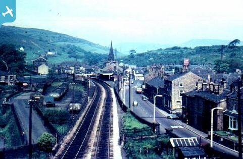
EPW013347 ENGLAND (1925). Bacup Road, the railway line and environs, Waterfoot, 1925

© Copyright OpenStreetMap contributors and licensed by the OpenStreetMap Foundation. 2024. Cartography is licensed as CC BY-SA.
Nearby Images (3)
EPW013347

EPW013345

EPW013346

Details
| Title | [EPW013347] Bacup Road, the railway line and environs, Waterfoot, 1925 |
| Reference | EPW013347 |
| Date | June-1925 |
| Link | |
| Place name | WATERFOOT |
| Parish | |
| District | |
| Country | ENGLAND |
| Easting / Northing | 383179, 421788 |
| Longitude / Latitude | -2.2547634459666, 53.692040364971 |
| National Grid Reference | SD832218 |
Pins
 Waterfoot William |
Friday 28th of June 2024 02:31:59 PM | |
Waterfoot William |
Friday 28th of June 2024 02:30:55 PM | |
Waterfoot William |
Friday 28th of June 2024 02:30:02 PM | |
Ralph Pomeroy |
Sunday 22nd of December 2019 04:21:25 PM | |
Boo |
Thursday 30th of April 2015 06:06:39 PM | |
Boo |
Thursday 30th of April 2015 06:04:00 PM | |
wadey |
Monday 24th of November 2014 02:01:04 PM | |
wadey |
Monday 24th of November 2014 02:00:02 PM | |
wadey |
Sunday 5th of October 2014 04:37:54 PM | |
wadey |
Sunday 5th of October 2014 04:36:50 PM | |
 BfA events |
Monday 22nd of April 2013 02:44:27 PM | |
BfA events |
Monday 22nd of April 2013 02:41:43 PM | |
BfA events |
Monday 22nd of April 2013 02:39:49 PM |