
EPW005686 ENGLAND (1921). St Huberts, Gerrards Cross, from the north-east, 1921

© Copyright OpenStreetMap contributors and licensed by the OpenStreetMap Foundation. 2025. Cartography is licensed as CC BY-SA.
Details
| Title | [EPW005686] St Huberts, Gerrards Cross, from the north-east, 1921 |
| Reference | EPW005686 |
| Date | March-1921 |
| Link | |
| Place name | GERRARDS CROSS |
| Parish | GERRARDS CROSS |
| District | |
| Country | ENGLAND |
| Easting / Northing | 501011, 187069 |
| Longitude / Latitude | -0.54227340281596, 51.572953479919 |
| National Grid Reference | TQ010871 |
Pins
User Comment Contributions
St Huberts House,Gerrards Cross ?? |
 martyk |
Tuesday 23rd of October 2012 12:54:12 PM |
It all fits. The house is so unusual that it can not be anywhere else. |
 Class31 |
Thursday 30th of August 2012 12:17:34 PM |
Thanks martyk. St Huberts House (listed grade II, I notice) it is; we can update the catalogue and the revised record with the correct location will appear here in due course. Yours, Katy Britain from Above Cataloguing Team Leader |
Katy Whitaker |
Tuesday 23rd of October 2012 12:54:12 PM |
St. Hubert's House, Gerrards Cross looking southwest. |
Class31 |
Thursday 30th of August 2012 12:19:33 PM |
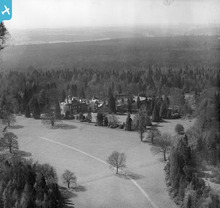 Interestingly mixed house with different styles (Italianate small tower, crenellations to left wing etc) and levels. |
Matthew Beckett - The Country Seat |
Sunday 1st of July 2012 08:17:00 PM |