
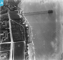
EPW001853 ENGLAND (1920). Hunstanton Pier and Esplanade Hall, Hunstanton, 1920

© Copyright OpenStreetMap contributors and licensed by the OpenStreetMap Foundation. 2025. Cartography is licensed as CC BY-SA.
Nearby Images (6)
EPW001853

EPW001996

EPW021526

EPW000851

EAW008204

EPW001850

Details
| Title | [EPW001853] Hunstanton Pier and Esplanade Hall, Hunstanton, 1920 |
| Reference | EPW001853 |
| Date | June-1920 |
| Link | |
| Place name | HUNSTANTON |
| Parish | HUNSTANTON |
| District | |
| Country | ENGLAND |
| Easting / Northing | 567168, 341199 |
| Longitude / Latitude | 0.48805014810505, 52.941791279992 |
| National Grid Reference | TF672412 |
Pins
 totoro |
Thursday 19th of March 2015 07:41:55 PM | |
totoro |
Thursday 19th of March 2015 07:38:49 PM | |
 melgibbs |
Wednesday 11th of March 2015 06:44:05 PM | |
melgibbs |
Sunday 23rd of June 2013 09:42:20 PM | |
For more details on the memorial, see www.roll-of-honour.com/Norfolk/Hunstanton.html. |
melgibbs |
Saturday 15th of February 2014 04:35:06 PM |
User Comment Contributions
 A good example of the Cenotaph style of memorial. |
melgibbs |
Wednesday 16th of April 2014 06:14:27 PM |