© Copyright OpenStreetMap contributors and licensed by the OpenStreetMap Foundation. 2024. Cartography is licensed as CC BY-SA.
Details
| Title |
[EPW000371] Promenade Pier, Dover, 1920 |
| Reference |
EPW000371 |
| Date |
April-1920 |
| Link |
|
| Place name |
DOVER |
| Parish |
DOVER |
| District |
|
| Country |
ENGLAND |
| Easting / Northing |
632358, 141243 |
| Longitude / Latitude |
1.3208564746607, 51.122740482418 |
| National Grid Reference |
TR324412 |
Pins
 Ruins of Old St James Church and the White Horse Inn, St James Street, Dover, UK.
The Duke of Wellington, as Lord Warden of the Cinque Ports, presided over the last Court of Lodemanage here in 1851.
St James the Apostle Church was destroyed during World War II. Now a war memorial and known as Dover's "Tidy Ruin".
The White Horse public house is said to date from the 14th Century.
The pub is currently run by Jeanette Harper and is a popular venue for cross-channel swimmers, many of who have signed their names on the walls and ceiling.
More information, including a Georgian woodcut engraving of the church, can be found at:
http://bit.ly/stjamesandwhitehorse
|

John Latter |
Tuesday 24th of July 2012 05:07:03 PM |
 Rare Panorama of the Napoleonic Canons Gate Caponier, Western Outer Curtain Wall, Dover Castle, Kent, UK. Also shows part of the mysterious Tudor Bulwark.
A caponier (caponnier) is a type of fortification that projects into the ditch (moat) of a fortress, traverses it completely to a detached outwork , or forms a blockhouse set in the "corners" of a moat-system like those surrounding the Drop Redoudt and North Centre Bastion on Dover's Western Heights.
Writing about Dover Castle in the seventh edition of a book first published in 1829, William Batcheller said:
"The New Entrance was constructed to the north-west of Canon-gate, in 1797, and has a drawbridge, a caponniere under it, a tete-du-pont, and other defences."
The "New Entrance" is today's Canons Gate (plural) while "Canon-gate" (singular) means the now-vanished Monk's Gate.
English Heritage and Listed Building. History.
More at:
http://www.panoramio.com/photo/56444278
|

John Latter |
Tuesday 24th of July 2012 04:50:41 PM |
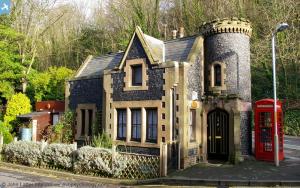
 The Gate House of Victoria Park, Castle Hill Road, Dover, Kent, UK.
The Victorian Gatehouse is situated on the west side of Victoria Park at the junction with Castle Hill Road.
The actual houses are on the east side in the form of a single terrace, they were built in 1864. The Zig Zags Park starts at the other end of the road (to the left).
The Gate House was once known as Castle Lodge; a Listed Building.
More detailed information can be found on this photo's original webpage at:
http://www.panoramio.com/photo/29690856
|

John Latter |
Tuesday 24th of July 2012 06:59:16 AM |


![[EPW000371] Promenade Pier, Dover, 1920](http://britainfromabove.org.uk/sites/all/libraries/aerofilms-images/public/100x100/EPW/000/EPW000371.jpg)
![[EAW007614] The town and seafront, Dover, from the south-east, 1947](http://britainfromabove.org.uk/sites/all/libraries/aerofilms-images/public/100x100/EAW/007/EAW007614.jpg)
![[EAW007617] The town and seafront, Dover, from the east, 1947](http://britainfromabove.org.uk/sites/all/libraries/aerofilms-images/public/100x100/EAW/007/EAW007617.jpg)
![[EAW007618] The town and seafront, Dover, from the south-east, 1947](http://britainfromabove.org.uk/sites/all/libraries/aerofilms-images/public/100x100/EAW/007/EAW007618.jpg)
![[EPW039375] Camden Crescent, the seafront and the town centre, Dover, 1932](http://britainfromabove.org.uk/sites/all/libraries/aerofilms-images/public/100x100/EPW/039/EPW039375.jpg)
![[EAW007613] The town and seafront, Dover, from the south-east, 1947](http://britainfromabove.org.uk/sites/all/libraries/aerofilms-images/public/100x100/EAW/007/EAW007613.jpg)
![[EAW007609] The town, Dover, from the east, 1947](http://britainfromabove.org.uk/sites/all/libraries/aerofilms-images/public/100x100/EAW/007/EAW007609.jpg)
![[EPW039372] The town centre and the seafront, Dover, 1932](http://britainfromabove.org.uk/sites/all/libraries/aerofilms-images/public/100x100/EPW/039/EPW039372.jpg)
![[EPW019057] Promenade Pier and Marine Parade, Dover, 1927. This image has been produced from a copy-negative.](http://britainfromabove.org.uk/sites/all/libraries/aerofilms-images/public/100x100/EPW/019/EPW019057.jpg)
![[EPW038153] The town centre, Dover, 1932. This image has been produced from a damaged negative.](http://britainfromabove.org.uk/sites/all/libraries/aerofilms-images/public/100x100/EPW/038/EPW038153.jpg)
![[EAW007608] The town, Dover, from the east, 1947](http://britainfromabove.org.uk/sites/all/libraries/aerofilms-images/public/100x100/EAW/007/EAW007608.jpg)
![[EPW038152] Liverpool Street and the town centre, Dover, 1932. This image has been produced from a copy-negative.](http://britainfromabove.org.uk/sites/all/libraries/aerofilms-images/public/100x100/EPW/038/EPW038152.jpg)
![[EPW039376] The town centre and the seafront, Dover, 1932](http://britainfromabove.org.uk/sites/all/libraries/aerofilms-images/public/100x100/EPW/039/EPW039376.jpg)
![[EPW035420] The town, the seafront and Dover Castle, Dover, from the south, 1931](http://britainfromabove.org.uk/sites/all/libraries/aerofilms-images/public/100x100/EPW/035/EPW035420.jpg)
![[EAW022988] Dover Castle and the harbours, Dover, 1949](http://britainfromabove.org.uk/sites/all/libraries/aerofilms-images/public/100x100/EAW/022/EAW022988.jpg)
![[EAW007611] The town, Dover, from the south-east, 1947](http://britainfromabove.org.uk/sites/all/libraries/aerofilms-images/public/100x100/EAW/007/EAW007611.jpg)
![[EPW039374] The town centre and the seafront, Dover, 1932. This image has been affected by flare.](http://britainfromabove.org.uk/sites/all/libraries/aerofilms-images/public/100x100/EPW/039/EPW039374.jpg)


