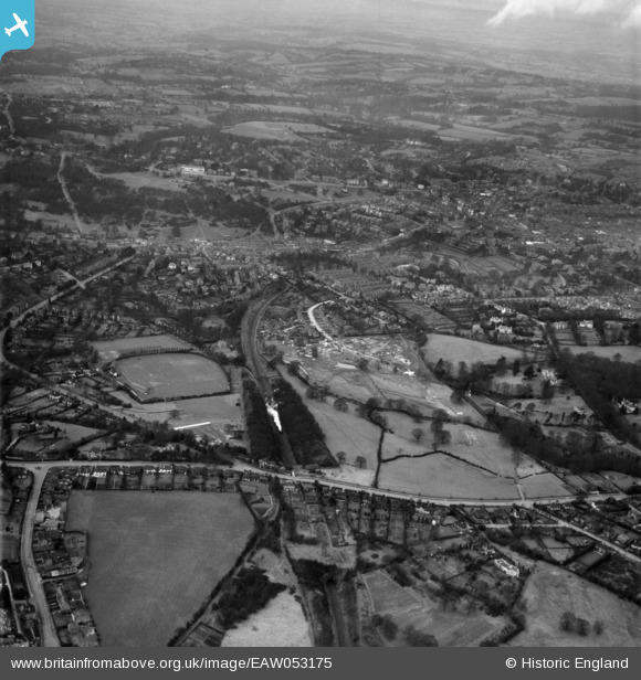
EAW053175 ENGLAND (1954). Banner Farm Estate in the early stages of construction, Tunbridge Wells Common and environs, Royal Tunbridge Wells, 1954
© Copyright OpenStreetMap contributors and licensed by the OpenStreetMap Foundation. 2024. Cartography is licensed as CC BY-SA.
Nearby Images (21)
Details
| Title | [EAW053175] Banner Farm Estate in the early stages of construction, Tunbridge Wells Common and environs, Royal Tunbridge Wells, 1954 |
| Reference | EAW053175 |
| Date | 22-February-1954 |
| Link | |
| Place name | ROYAL TUNBRIDGE WELLS |
| Parish | |
| District | |
| Country | ENGLAND |
| Easting / Northing | 558807, 138697 |
| Longitude / Latitude | 0.26963339329428, 51.124984091198 |
| National Grid Reference | TQ588387 |


![[EAW053175] Banner Farm Estate in the early stages of construction, Tunbridge Wells Common and environs, Royal Tunbridge Wells, 1954](http://britainfromabove.org.uk/sites/all/libraries/aerofilms-images/public/100x100/EAW/053/EAW053175.jpg)
![[EPW032966] Nevill Cricket and Athletic Ground, Cambridge Gardens and environs, Royal Tunbridge Wells, 1930](http://britainfromabove.org.uk/sites/all/libraries/aerofilms-images/public/100x100/EPW/032/EPW032966.jpg)
![[EAW053167] Banner Farm Estate in the early stages of construction, Tunbridge Wells Common and environs, Royal Tunbridge Wells, 1954](http://britainfromabove.org.uk/sites/all/libraries/aerofilms-images/public/100x100/EAW/053/EAW053167.jpg)
![[EAW053176] Banner Farm Estate in the early stages of construction, Royal Tunbridge Wells, 1954](http://britainfromabove.org.uk/sites/all/libraries/aerofilms-images/public/100x100/EAW/053/EAW053176.jpg)
![[EPW032960] Nevill Cricket and Athletic Ground and housing around Arundel Road, Royal Tunbridge Wells, 1930](http://britainfromabove.org.uk/sites/all/libraries/aerofilms-images/public/100x100/EPW/032/EPW032960.jpg)
![[EPW032959] Claremont Road and environs, Royal Tunbridge Wells, 1930](http://britainfromabove.org.uk/sites/all/libraries/aerofilms-images/public/100x100/EPW/032/EPW032959.jpg)
![[EPW032964] Claremont Road and environs, Royal Tunbridge Wells, 1930](http://britainfromabove.org.uk/sites/all/libraries/aerofilms-images/public/100x100/EPW/032/EPW032964.jpg)
![[EPW032963] Madeira Park, Claremont Road and environs, Royal Tunbridge Wells, 1930](http://britainfromabove.org.uk/sites/all/libraries/aerofilms-images/public/100x100/EPW/032/EPW032963.jpg)
![[EPW032968] Madeira Park, Claremont Road and environs, Royal Tunbridge Wells, 1930](http://britainfromabove.org.uk/sites/all/libraries/aerofilms-images/public/100x100/EPW/032/EPW032968.jpg)
![[EPW032961] Claremont Road and environs, Royal Tunbridge Wells, 1930](http://britainfromabove.org.uk/sites/all/libraries/aerofilms-images/public/100x100/EPW/032/EPW032961.jpg)
![[EAW053174] Banner Farm Estate in the early stages of construction, Royal Tunbridge Wells, 1954](http://britainfromabove.org.uk/sites/all/libraries/aerofilms-images/public/100x100/EAW/053/EAW053174.jpg)
![[EPW032962] Madeira Park and environs, Royal Tunbridge Wells, 1930](http://britainfromabove.org.uk/sites/all/libraries/aerofilms-images/public/100x100/EPW/032/EPW032962.jpg)
![[EAW053171] Banner Farm Estate in the early stages of construction, Tunbridge Wells Common and environs, Royal Tunbridge Wells, 1954](http://britainfromabove.org.uk/sites/all/libraries/aerofilms-images/public/100x100/EAW/053/EAW053171.jpg)
![[EAW053173] Banner Farm Estate in the early stages of construction, Royal Tunbridge Wells, 1954](http://britainfromabove.org.uk/sites/all/libraries/aerofilms-images/public/100x100/EAW/053/EAW053173.jpg)
![[EAW053168] Banner Farm Estate in the early stages of construction, Royal Tunbridge Wells, 1954](http://britainfromabove.org.uk/sites/all/libraries/aerofilms-images/public/100x100/EAW/053/EAW053168.jpg)
![[EPW032967] Claremont Road and environs, Royal Tunbridge Wells, 1930](http://britainfromabove.org.uk/sites/all/libraries/aerofilms-images/public/100x100/EPW/032/EPW032967.jpg)
![[EPW032971] The town around Calverley Park, Royal Tunbridge Wells, from the south-west, 1930](http://britainfromabove.org.uk/sites/all/libraries/aerofilms-images/public/100x100/EPW/032/EPW032971.jpg)
![[EPW032965] Nevill Cricket and Athletic Ground, Claremont Road and environs, Royal Tunbridge Wells, 1930](http://britainfromabove.org.uk/sites/all/libraries/aerofilms-images/public/100x100/EPW/032/EPW032965.jpg)
![[EAW053172] Banner Farm Estate in the early stages of construction, Royal Tunbridge Wells, 1954](http://britainfromabove.org.uk/sites/all/libraries/aerofilms-images/public/100x100/EAW/053/EAW053172.jpg)
![[EAW053169] Banner Farm Estate in the early stages of construction and environs, Royal Tunbridge Wells, 1954](http://britainfromabove.org.uk/sites/all/libraries/aerofilms-images/public/100x100/EAW/053/EAW053169.jpg)
![[EAW053170] Banner Farm Estate in the early stages of construction, Camden Park and environs, Royal Tunbridge Wells, 1954](http://britainfromabove.org.uk/sites/all/libraries/aerofilms-images/public/100x100/EAW/053/EAW053170.jpg)
