
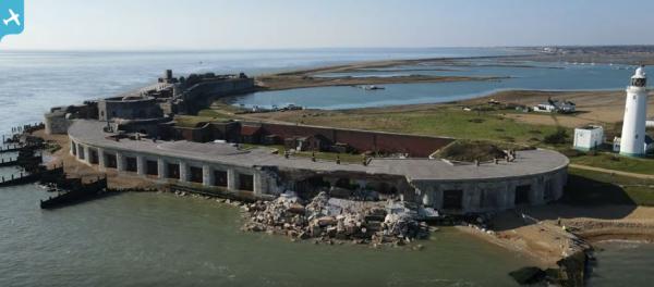
EAW050048 ENGLAND (1953). Hurst Castle, Keyhaven, 1953

© Copyright OpenStreetMap contributors and licensed by the OpenStreetMap Foundation. 2025. Cartography is licensed as CC BY-SA.
Nearby Images (5)
EAW050048

EAW038617
 and The Solent, Milford on Sea, from the south-west, 1951. This image has been produced from a damaged negative.")
EAW050047

EAW038616
, Milford on Sea, 1951. This image has been produced from a damaged negative.")
EAW049061

Details
| Title | [EAW050048] Hurst Castle, Keyhaven, 1953 |
| Reference | EAW050048 |
| Date | 18-June-1953 |
| Link | |
| Place name | KEYHAVEN |
| Parish | MILFORD-ON-SEA |
| District | |
| Country | ENGLAND |
| Easting / Northing | 431718, 89769 |
| Longitude / Latitude | -1.5507685624563, 50.70611680714 |
| National Grid Reference | SZ317898 |
Pins
 Matt Aldred edob.mattaldred.com |
Wednesday 6th of March 2024 07:19:53 PM | |
 |
 Nat Chuff |
Sunday 7th of March 2021 02:15:16 PM |
Sweet Pete |
Wednesday 11th of February 2015 04:58:50 PM | |
jrussill |
Thursday 13th of November 2014 04:59:12 PM |
