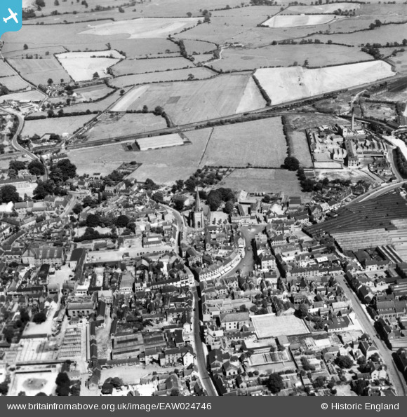
EAW024746 ENGLAND (1949). The town centre, Uttoxeter, 1949. This image has been produced from a print.
© Copyright OpenStreetMap contributors and licensed by the OpenStreetMap Foundation. 2025. Cartography is licensed as CC BY-SA.
Nearby Images (7)
Details
| Title | [EAW024746] The town centre, Uttoxeter, 1949. This image has been produced from a print. |
| Reference | EAW024746 |
| Date | 11-July-1949 |
| Link | |
| Place name | UTTOXETER |
| Parish | UTTOXETER |
| District | |
| Country | ENGLAND |
| Easting / Northing | 409389, 333499 |
| Longitude / Latitude | -1.8604096698983, 52.898531384193 |
| National Grid Reference | SK094335 |
Pins
 cidge |
Monday 23rd of July 2018 12:44:28 PM | |
 cidge |
Monday 23rd of July 2018 12:42:47 PM | |
 cidge |
Monday 23rd of July 2018 12:41:03 PM | |
 cidge |
Monday 23rd of July 2018 12:39:27 PM | |
 cidge |
Monday 23rd of July 2018 12:38:19 PM | |
 cidge |
Monday 23rd of July 2018 12:36:49 PM | |
 cidge |
Monday 23rd of July 2018 12:35:59 PM | |
 cidge |
Monday 23rd of July 2018 12:29:03 PM | |
 cidge |
Monday 23rd of July 2018 12:27:52 PM | |
 cidge |
Monday 23rd of July 2018 09:51:09 AM | |
 cidge |
Monday 23rd of July 2018 09:45:49 AM |


![[EAW024746] The town centre, Uttoxeter, 1949. This image has been produced from a print.](http://britainfromabove.org.uk/sites/all/libraries/aerofilms-images/public/100x100/EAW/024/EAW024746.jpg)
![[EPW058388] St Mary's Church and the Market Place, Uttoxeter, 1938](http://britainfromabove.org.uk/sites/all/libraries/aerofilms-images/public/100x100/EPW/058/EPW058388.jpg)
![[EPW058413] St Mary's Church and the town centre, Uttoxeter, 1938](http://britainfromabove.org.uk/sites/all/libraries/aerofilms-images/public/100x100/EPW/058/EPW058413.jpg)
![[EPW020036] The Leighton Iron Works and the town, Uttoxeter, 1927](http://britainfromabove.org.uk/sites/all/libraries/aerofilms-images/public/100x100/EPW/020/EPW020036.jpg)
![[EPW020035] The Leighton Iron Works and the town, Uttoxeter, 1927](http://britainfromabove.org.uk/sites/all/libraries/aerofilms-images/public/100x100/EPW/020/EPW020035.jpg)
![[EPW012625] The town centre, Uttoxeter, 1925. This image has been produced from a copy-negative.](http://britainfromabove.org.uk/sites/all/libraries/aerofilms-images/public/100x100/EPW/012/EPW012625.jpg)
![[EPW020033] The Leighton Iron Works and environs, Uttoxeter, 1927](http://britainfromabove.org.uk/sites/all/libraries/aerofilms-images/public/100x100/EPW/020/EPW020033.jpg)