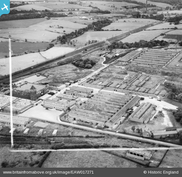
EAW017271 ENGLAND (1948). H. J. Heinz Co Ltd Factory, Standish, 1948. This image has been produced from a print marked by Aerofilms Ltd for photo editing.
© Copyright OpenStreetMap contributors and licensed by the OpenStreetMap Foundation. 2024. Cartography is licensed as CC BY-SA.
Nearby Images (21)
Details
| Title | [EAW017271] H. J. Heinz Co Ltd Factory, Standish, 1948. This image has been produced from a print marked by Aerofilms Ltd for photo editing. |
| Reference | EAW017271 |
| Date | 19-July-1948 |
| Link | |
| Place name | STANDISH |
| Parish | |
| District | |
| Country | ENGLAND |
| Easting / Northing | 357201, 411074 |
| Longitude / Latitude | -2.6467205174579, 53.5942529134 |
| National Grid Reference | SD572111 |
Pins
 Matt Aldred edob.mattaldred.com |
Friday 8th of March 2024 07:37:41 PM | |
 Matt Aldred edob.mattaldred.com |
Wednesday 6th of October 2021 02:49:54 PM | |
 Matt Aldred edob.mattaldred.com |
Wednesday 6th of October 2021 02:49:32 PM | |
 Matt Aldred edob.mattaldred.com |
Wednesday 6th of October 2021 02:24:37 PM |


![[EAW017271] H. J. Heinz Co Ltd Factory, Standish, 1948. This image has been produced from a print marked by Aerofilms Ltd for photo editing.](http://britainfromabove.org.uk/sites/all/libraries/aerofilms-images/public/100x100/EAW/017/EAW017271.jpg)
![[EAW017269] H. J. Heinz Co Ltd Factory, Standish, 1948. This image has been produced from a print marked by Aerofilms Ltd for photo editing.](http://britainfromabove.org.uk/sites/all/libraries/aerofilms-images/public/100x100/EAW/017/EAW017269.jpg)
![[EAW017266] H. J. Heinz Co Ltd Factory and environs, Standish, 1948. This image has been produced from a print marked by Aerofilms Ltd for photo editing.](http://britainfromabove.org.uk/sites/all/libraries/aerofilms-images/public/100x100/EAW/017/EAW017266.jpg)
![[EAW032683] The Carrington and Dewhurst Ltd Douglas Mill, Standish, 1950](http://britainfromabove.org.uk/sites/all/libraries/aerofilms-images/public/100x100/EAW/032/EAW032683.jpg)
![[EAW032674] The Carrington and Dewhurst Ltd Douglas Mill, Standish, 1950](http://britainfromabove.org.uk/sites/all/libraries/aerofilms-images/public/100x100/EAW/032/EAW032674.jpg)
![[EAW032676] The Carrington and Dewhurst Ltd Douglas Mill, Standish, 1950](http://britainfromabove.org.uk/sites/all/libraries/aerofilms-images/public/100x100/EAW/032/EAW032676.jpg)
![[EAW032672] The Carrington and Dewhurst Ltd Douglas Mill, Standish, 1950. This image was marked by Aerofilms Ltd for photo editing.](http://britainfromabove.org.uk/sites/all/libraries/aerofilms-images/public/100x100/EAW/032/EAW032672.jpg)
![[EAW032675] The Carrington and Dewhurst Ltd Douglas Mill, Standish, 1950](http://britainfromabove.org.uk/sites/all/libraries/aerofilms-images/public/100x100/EAW/032/EAW032675.jpg)
![[EAW017273] H. J. Heinz Co Ltd Factory, Standish, 1948. This image has been produced from a print marked by Aerofilms Ltd for photo editing.](http://britainfromabove.org.uk/sites/all/libraries/aerofilms-images/public/100x100/EAW/017/EAW017273.jpg)
![[EAW032679] The Carrington and Dewhurst Ltd Douglas Mill, Standish, 1950. This image was marked by Aerofilms Ltd for photo editing.](http://britainfromabove.org.uk/sites/all/libraries/aerofilms-images/public/100x100/EAW/032/EAW032679.jpg)
![[EAW032678] The Carrington and Dewhurst Ltd Douglas Mill, Standish, 1950](http://britainfromabove.org.uk/sites/all/libraries/aerofilms-images/public/100x100/EAW/032/EAW032678.jpg)
![[EAW017274] H. J. Heinz Co Ltd Factory, Standish, 1948. This image has been produced from a print marked by Aerofilms Ltd for photo editing.](http://britainfromabove.org.uk/sites/all/libraries/aerofilms-images/public/100x100/EAW/017/EAW017274.jpg)
![[EAW032677] The Carrington and Dewhurst Ltd Douglas Mill, Standish, 1950. This image was marked by Aerofilms Ltd for photo editing.](http://britainfromabove.org.uk/sites/all/libraries/aerofilms-images/public/100x100/EAW/032/EAW032677.jpg)
![[EAW032681] The Carrington and Dewhurst Ltd Douglas Mill, Standish, 1950](http://britainfromabove.org.uk/sites/all/libraries/aerofilms-images/public/100x100/EAW/032/EAW032681.jpg)
![[EAW017268] H. J. Heinz Co Ltd Factory, Standish, from the north, 1948. This image has been produced from a print marked by Aerofilms Ltd for photo editing.](http://britainfromabove.org.uk/sites/all/libraries/aerofilms-images/public/100x100/EAW/017/EAW017268.jpg)
![[EAW032680] The Carrington and Dewhurst Ltd Douglas Mill, Standish, 1950. This image was marked by Aerofilms Ltd for photo editing.](http://britainfromabove.org.uk/sites/all/libraries/aerofilms-images/public/100x100/EAW/032/EAW032680.jpg)
![[EAW032682] The Carrington and Dewhurst Ltd Douglas Mill, Standish, 1950](http://britainfromabove.org.uk/sites/all/libraries/aerofilms-images/public/100x100/EAW/032/EAW032682.jpg)
![[EAW017270] H. J. Heinz Co Ltd Factory, Standish, 1948. This image has been produced from a print marked by Aerofilms Ltd for photo editing.](http://britainfromabove.org.uk/sites/all/libraries/aerofilms-images/public/100x100/EAW/017/EAW017270.jpg)
![[EAW032673] The Carrington and Dewhurst Ltd Douglas Mill, Standish, 1950. This image was marked by Aerofilms Ltd for photo editing.](http://britainfromabove.org.uk/sites/all/libraries/aerofilms-images/public/100x100/EAW/032/EAW032673.jpg)
![[EAW017267] H. J. Heinz Co Ltd Factory and environs, Standish, 1948. This image has been produced from a print marked by Aerofilms Ltd for photo editing.](http://britainfromabove.org.uk/sites/all/libraries/aerofilms-images/public/100x100/EAW/017/EAW017267.jpg)
![[EAW017272] H. J. Heinz Co Ltd Factory, Standish, 1948. This image has been produced from a print marked by Aerofilms Ltd for photo editing.](http://britainfromabove.org.uk/sites/all/libraries/aerofilms-images/public/100x100/EAW/017/EAW017272.jpg)