
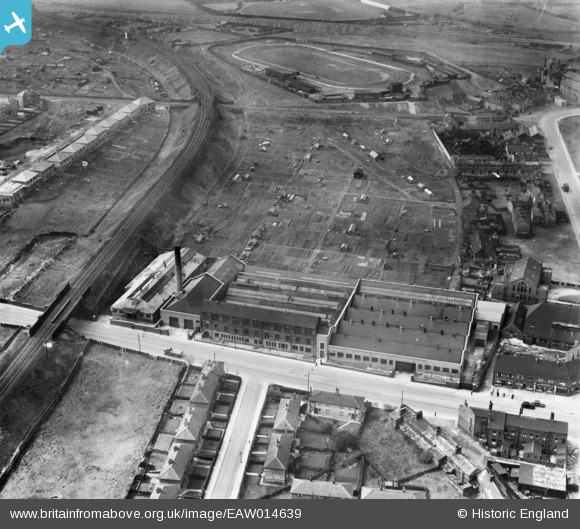
EAW014639 ENGLAND (1948). The Cooperative Wholesale Society Brush Works on Belle Isle Road and adjacent allotments, Hunslet Carr, 1948
© Copyright OpenStreetMap contributors and licensed by the OpenStreetMap Foundation. 2025. Cartography is licensed as CC BY-SA.
Nearby Images (6)
EAW014639

EAW014640

EAW014635

EAW014637

EAW014636
EAW014638
Details
| Title | [EAW014639] The Cooperative Wholesale Society Brush Works on Belle Isle Road and adjacent allotments, Hunslet Carr, 1948 |
| Reference | EAW014639 |
| Date | 21-April-1948 |
| Link | |
| Place name | HUNSLET CARR |
| Parish | |
| District | |
| Country | ENGLAND |
| Easting / Northing | 430904, 430634 |
| Longitude / Latitude | -1.5310636347202, 53.770911918737 |
| National Grid Reference | SE309306 |
Pins
 redmist |
Monday 14th of October 2019 08:50:44 PM | |
gerry-r |
Monday 16th of June 2014 11:36:50 PM | |
gerry-r |
Monday 16th of June 2014 11:31:29 PM | |
Brick Collector |
Sunday 16th of February 2014 09:06:27 PM |