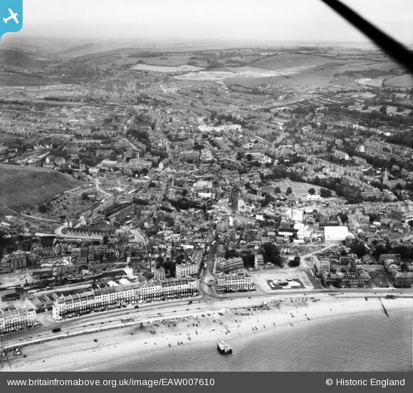
EAW007610 ENGLAND (1947). The town, Dover, from the south-east, 1947
© Copyright OpenStreetMap contributors and licensed by the OpenStreetMap Foundation. 2024. Cartography is licensed as CC BY-SA.
Nearby Images (20)
Details
| Title | [EAW007610] The town, Dover, from the south-east, 1947 |
| Reference | EAW007610 |
| Date | 28-June-1947 |
| Link | |
| Place name | DOVER |
| Parish | DOVER |
| District | |
| Country | ENGLAND |
| Easting / Northing | 632050, 141178 |
| Longitude / Latitude | 1.3164206158782, 51.12228173976 |
| National Grid Reference | TR321412 |
Pins
 Sparky |
Monday 2nd of October 2017 11:29:12 PM | |
 Alan McFaden |
Wednesday 9th of July 2014 05:42:04 PM | |
 Alan McFaden |
Wednesday 9th of July 2014 05:41:24 PM | |
 Alan McFaden |
Wednesday 9th of July 2014 05:40:14 PM | |
 Alan McFaden |
Wednesday 9th of July 2014 05:39:05 PM | |
 Alan McFaden |
Wednesday 9th of July 2014 05:37:52 PM |


![[EAW007610] The town, Dover, from the south-east, 1947](http://britainfromabove.org.uk/sites/all/libraries/aerofilms-images/public/100x100/EAW/007/EAW007610.jpg)
![[EPW000579] Waterloo Crescent and Promenade Pier, Dover, 1920](http://britainfromabove.org.uk/sites/all/libraries/aerofilms-images/public/100x100/EPW/000/EPW000579.jpg)
![[EAW007606] The town and seafront, Dover, from the south-east, 1947](http://britainfromabove.org.uk/sites/all/libraries/aerofilms-images/public/100x100/EAW/007/EAW007606.jpg)
![[EPW035420] The town, the seafront and Dover Castle, Dover, from the south, 1931](http://britainfromabove.org.uk/sites/all/libraries/aerofilms-images/public/100x100/EPW/035/EPW035420.jpg)
![[EPW039376] The town centre and the seafront, Dover, 1932](http://britainfromabove.org.uk/sites/all/libraries/aerofilms-images/public/100x100/EPW/039/EPW039376.jpg)
![[EAW007612] The town, Dover, from the south-east, 1947](http://britainfromabove.org.uk/sites/all/libraries/aerofilms-images/public/100x100/EAW/007/EAW007612.jpg)
![[EPW019057] Promenade Pier and Marine Parade, Dover, 1927. This image has been produced from a copy-negative.](http://britainfromabove.org.uk/sites/all/libraries/aerofilms-images/public/100x100/EPW/019/EPW019057.jpg)
![[EPW039374] The town centre and the seafront, Dover, 1932. This image has been affected by flare.](http://britainfromabove.org.uk/sites/all/libraries/aerofilms-images/public/100x100/EPW/039/EPW039374.jpg)
![[EAW007618] The town and seafront, Dover, from the south-east, 1947](http://britainfromabove.org.uk/sites/all/libraries/aerofilms-images/public/100x100/EAW/007/EAW007618.jpg)
![[EPW038155] The town centre, Dover, 1932](http://britainfromabove.org.uk/sites/all/libraries/aerofilms-images/public/100x100/EPW/038/EPW038155.jpg)
![[EPW039375] Camden Crescent, the seafront and the town centre, Dover, 1932](http://britainfromabove.org.uk/sites/all/libraries/aerofilms-images/public/100x100/EPW/039/EPW039375.jpg)
![[EPW000356] Central Dover and the Wellington Basin, Dover, 1920](http://britainfromabove.org.uk/sites/all/libraries/aerofilms-images/public/100x100/EPW/000/EPW000356.jpg)
![[EAW007611] The town, Dover, from the south-east, 1947](http://britainfromabove.org.uk/sites/all/libraries/aerofilms-images/public/100x100/EAW/007/EAW007611.jpg)
![[EAW007613] The town and seafront, Dover, from the south-east, 1947](http://britainfromabove.org.uk/sites/all/libraries/aerofilms-images/public/100x100/EAW/007/EAW007613.jpg)
![[EPW000773] The Market Square, Dover, 1920](http://britainfromabove.org.uk/sites/all/libraries/aerofilms-images/public/100x100/EPW/000/EPW000773.jpg)
![[EPW035419] The town and seafront, Dover, 1931](http://britainfromabove.org.uk/sites/all/libraries/aerofilms-images/public/100x100/EPW/035/EPW035419.jpg)
![[EPW038152] Liverpool Street and the town centre, Dover, 1932. This image has been produced from a copy-negative.](http://britainfromabove.org.uk/sites/all/libraries/aerofilms-images/public/100x100/EPW/038/EPW038152.jpg)
![[EPW039372] The town centre and the seafront, Dover, 1932](http://britainfromabove.org.uk/sites/all/libraries/aerofilms-images/public/100x100/EPW/039/EPW039372.jpg)
![[EAW007609] The town, Dover, from the east, 1947](http://britainfromabove.org.uk/sites/all/libraries/aerofilms-images/public/100x100/EAW/007/EAW007609.jpg)
![[EPW038153] The town centre, Dover, 1932. This image has been produced from a damaged negative.](http://britainfromabove.org.uk/sites/all/libraries/aerofilms-images/public/100x100/EPW/038/EPW038153.jpg)


