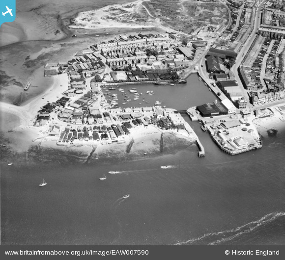
EAW007590 ENGLAND (1947). Exmouth Dock, Exmouth, 1947
© Copyright OpenStreetMap contributors and licensed by the OpenStreetMap Foundation. 2025. Cartography is licensed as CC BY-SA.
Nearby Images (12)
Details
| Title | [EAW007590] Exmouth Dock, Exmouth, 1947 |
| Reference | EAW007590 |
| Date | 26-June-1947 |
| Link | |
| Place name | EXMOUTH |
| Parish | EXMOUTH |
| District | |
| Country | ENGLAND |
| Easting / Northing | 299300, 80720 |
| Longitude / Latitude | -3.4235697075707, 50.616900304533 |
| National Grid Reference | SX993807 |
Pins
 redmist |
Wednesday 11th of January 2023 11:03:54 PM | |
 redmist |
Wednesday 11th of January 2023 11:02:52 PM | |
 redmist |
Wednesday 11th of January 2023 11:02:10 PM | |
 redmist |
Tuesday 10th of January 2023 08:54:22 PM | |
 Al |
Monday 15th of September 2014 09:31:06 PM |
User Comment Contributions
 Al |
Monday 15th of September 2014 09:31:59 PM |


![[EAW007590] Exmouth Dock, Exmouth, 1947](http://britainfromabove.org.uk/sites/all/libraries/aerofilms-images/public/100x100/EAW/007/EAW007590.jpg)
![[EPW023675] The Point, Exmouth, from the south-west, 1928.](http://britainfromabove.org.uk/sites/all/libraries/aerofilms-images/public/100x100/EPW/023/EPW023675.jpg)
![[EPW033462] The Dock and Pier at The Point, Exmouth, 1930](http://britainfromabove.org.uk/sites/all/libraries/aerofilms-images/public/100x100/EPW/033/EPW033462.jpg)
![[EPW023676] Pier Head and the Dock, Exmouth, 1928.](http://britainfromabove.org.uk/sites/all/libraries/aerofilms-images/public/100x100/EPW/023/EPW023676.jpg)
![[EPW033465] The Point, Exmouth, 1930](http://britainfromabove.org.uk/sites/all/libraries/aerofilms-images/public/100x100/EPW/033/EPW033465.jpg)
![[EAW051152] Exmouth Dock and The Point, Exmouth, 1953](http://britainfromabove.org.uk/sites/all/libraries/aerofilms-images/public/100x100/EAW/051/EAW051152.jpg)
![[EPW033467] The Point, Cockle Sand, the town and surrounding countryside, Exmouth, from the west, 1930. This image has been affected by flare.](http://britainfromabove.org.uk/sites/all/libraries/aerofilms-images/public/100x100/EPW/033/EPW033467.jpg)
![[EAW051153] Exmouth Dock, The Point and environs, Exmouth, 1953](http://britainfromabove.org.uk/sites/all/libraries/aerofilms-images/public/100x100/EAW/051/EAW051153.jpg)
![[EPW023674] The Point, Exmouth, from the south-west, 1928.](http://britainfromabove.org.uk/sites/all/libraries/aerofilms-images/public/100x100/EPW/023/EPW023674.jpg)
![[EPW039693] The docks and environs, Exmouth, 1932](http://britainfromabove.org.uk/sites/all/libraries/aerofilms-images/public/100x100/EPW/039/EPW039693.jpg)
![[EPW023666] The Dock, Exmouth, 1928.](http://britainfromabove.org.uk/sites/all/libraries/aerofilms-images/public/100x100/EPW/023/EPW023666.jpg)
![[EPW033463] The Point, Cockle Sand, the town and surrounding countryside, Exmouth, from the west, 1930](http://britainfromabove.org.uk/sites/all/libraries/aerofilms-images/public/100x100/EPW/033/EPW033463.jpg)
