
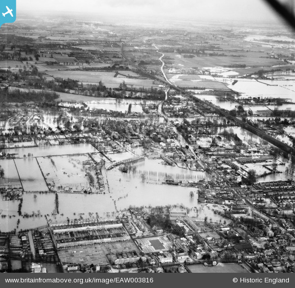
EAW003816 ENGLAND (1947). Flooding around Bridge Road and environs, Maidenhead, from the north-west, 1947
© Copyright OpenStreetMap contributors and licensed by the OpenStreetMap Foundation. 2024. Cartography is licensed as CC BY-SA.
Nearby Images (3)
EAW003816

EAW003815

EPW000901

Details
| Title | [EAW003816] Flooding around Bridge Road and environs, Maidenhead, from the north-west, 1947 |
| Reference | EAW003816 |
| Date | 19-March-1947 |
| Link | |
| Place name | MAIDENHEAD |
| Parish | |
| District | |
| Country | ENGLAND |
| Easting / Northing | 489504, 181522 |
| Longitude / Latitude | -0.70969849872796, 51.525029954137 |
| National Grid Reference | SU895815 |
Pins
 designking |
Wednesday 31st of January 2024 10:13:16 PM | |
designking |
Wednesday 31st of January 2024 10:11:09 PM | |
designking |
Wednesday 31st of January 2024 10:10:03 PM | |
William Hester |
Tuesday 21st of June 2016 01:29:06 AM | |
William Hester |
Tuesday 21st of June 2016 01:26:11 AM | |
William Hester |
Tuesday 21st of June 2016 01:25:17 AM | |
William Hester |
Tuesday 21st of June 2016 01:15:03 AM | |
William Hester |
Tuesday 21st of June 2016 01:15:03 AM | |
William Hester |
Tuesday 21st of June 2016 01:13:44 AM | |
William Hester |
Tuesday 21st of June 2016 01:12:45 AM |