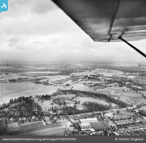
EAW003684 ENGLAND (1947). The River Thames in flood surrounding Woburn Park and the Chertsey Meads, Hamm Moor, from the south-west, 1947
© Copyright OpenStreetMap contributors and licensed by the OpenStreetMap Foundation. 2024. Cartography is licensed as CC BY-SA.
Details
| Title | [EAW003684] The River Thames in flood surrounding Woburn Park and the Chertsey Meads, Hamm Moor, from the south-west, 1947 |
| Reference | EAW003684 |
| Date | 18-March-1947 |
| Link | |
| Place name | HAMM MOOR |
| Parish | |
| District | |
| Country | ENGLAND |
| Easting / Northing | 506021, 165386 |
| Longitude / Latitude | -0.47650761687189, 51.377117295353 |
| National Grid Reference | TQ060654 |
Pins
 Matt Aldred edob.mattaldred.com |
Wednesday 31st of July 2024 03:57:30 PM | |
 Matt Aldred edob.mattaldred.com |
Wednesday 31st of July 2024 03:56:41 PM | |
 tima |
Friday 19th of April 2019 08:58:29 AM | |
 mpg |
Wednesday 29th of October 2014 10:33:43 PM | |
 mpg |
Wednesday 29th of October 2014 10:31:33 PM |


![[EAW003684] The River Thames in flood surrounding Woburn Park and the Chertsey Meads, Hamm Moor, from the south-west, 1947](http://britainfromabove.org.uk/sites/all/libraries/aerofilms-images/public/100x100/EAW/003/EAW003684.jpg)
![[EPW049543] River Thames in flood around Chertsey Mead, Woburn Park and environs, Addlestone, from the south-east, 1936](http://britainfromabove.org.uk/sites/all/libraries/aerofilms-images/public/100x100/EPW/049/EPW049543.jpg)
![[EPW049545] River Thames in flood around Woburn Park, Addlestone, from the south-east, 1936](http://britainfromabove.org.uk/sites/all/libraries/aerofilms-images/public/100x100/EPW/049/EPW049545.jpg)