
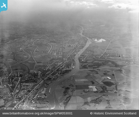
SPW053001 SCOTLAND (1937). River Clyde, general view, showing Clydebank and Scotstoun. An oblique aerial photograph taken facing east.
© Hawlfraint cyfranwyr OpenStreetMap a thrwyddedwyd gan yr OpenStreetMap Foundation. 2024. Trwyddedir y gartograffeg fel CC BY-SA.
Manylion
| Pennawd | [SPW053001] River Clyde, general view, showing Clydebank and Scotstoun. An oblique aerial photograph taken facing east. |
| Cyfeirnod | SPW053001 |
| Dyddiad | 1937 |
| Dolen | Canmore Collection item 1258105 |
| Enw lle | |
| Plwyf | RENFREW (CITY OF GLASGOW) |
| Ardal | CITY OF GLASGOW |
| Gwlad | SCOTLAND |
| Dwyreiniad / Gogleddiad | 251460, 668400 |
| Hydred / Lledred | -4.375163517564, 55.885830635819 |
| Cyfeirnod Grid Cenedlaethol | NS515684 |
Pinnau
 ie |
Tuesday 20th of September 2022 09:48:56 AM | |
ie |
Tuesday 20th of September 2022 09:47:35 AM | |
ie |
Tuesday 20th of September 2022 09:46:13 AM | |
ie |
Tuesday 20th of September 2022 09:45:23 AM | |
ie |
Tuesday 20th of September 2022 09:44:28 AM | |
bankie |
Wednesday 29th of July 2020 10:01:23 PM | |
kgs |
Tuesday 22nd of January 2013 04:02:09 PM | |
Donald Marshall |
Monday 14th of January 2013 01:57:17 AM | |
abc |
Saturday 15th of December 2012 12:15:38 PM | |
bankie |
Friday 23rd of November 2012 01:05:18 AM | |
atteded O.H.R. school hated when the sulphur boat unloaded approx once a year memory says March/April time red eyes from sulphur dust |
bankie |
Friday 23rd of November 2012 01:19:25 AM |
Julie |
Saturday 27th of October 2012 07:30:40 PM | |
Gerry_R |
Friday 26th of October 2012 09:17:24 AM | |
Gerry_R |
Friday 26th of October 2012 09:16:32 AM | |
Gerry_R |
Friday 26th of October 2012 09:15:43 AM | |
Gerry_R |
Friday 26th of October 2012 09:14:34 AM | |
Weechookieburdie |
Wednesday 24th of October 2012 02:09:29 AM | |
Weechookieburdie |
Wednesday 24th of October 2012 02:06:20 AM | |
Weechookieburdie |
Wednesday 24th of October 2012 02:04:20 AM | |
Weechookieburdie |
Wednesday 24th of October 2012 02:00:27 AM | |
Weechookieburdie |
Wednesday 24th of October 2012 01:57:11 AM | |
Weechookieburdie |
Wednesday 24th of October 2012 01:53:53 AM | |
Weechookieburdie |
Wednesday 24th of October 2012 01:52:33 AM | |
My Great grandfather,grandfather,grandmother as wll as uncles and aunts perished at 76 second avenue on the first night of the Blitz. |
john divers |
Tuesday 2nd of December 2014 07:25:37 PM |
Weechookieburdie |
Wednesday 24th of October 2012 01:48:46 AM | |
Weechookieburdie |
Wednesday 24th of October 2012 01:46:59 AM | |
Gerry_R |
Thursday 18th of October 2012 09:38:29 AM | |
Gerry_R |
Thursday 18th of October 2012 09:36:14 AM | |
Gerry_R |
Thursday 18th of October 2012 09:31:51 AM | |
morseman |
Thursday 16th of August 2012 05:15:24 PM | |
morseman |
Thursday 16th of August 2012 05:14:09 PM |
Cyfraniadau Grŵp
I,ve been searching for old aerial images of Drumchapel without much success. Present day Drumchapel stands where the railway line stretches into the distance on the left hand side of this photograph. |
DavidT |
Tuesday 26th of June 2012 11:43:03 AM |


