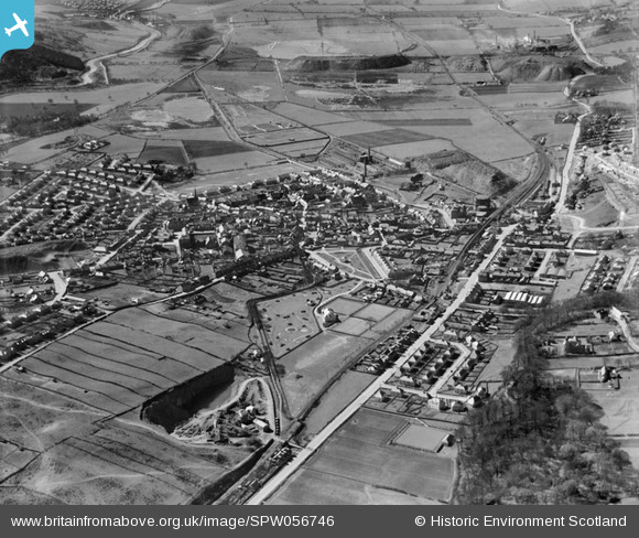
spw056746 SCOTLAND (1938). Kilsyth, general view, showing Burngreen Park and Stirling Road. An oblique aerial photograph taken facing south-west.
© Copyright OpenStreetMap contributors and licensed by the OpenStreetMap Foundation. 2025. Cartography is licensed as CC BY-SA.
Nearby Images (6)
Details
| Title | [SPW056746] Kilsyth, general view, showing Burngreen Park and Stirling Road. An oblique aerial photograph taken facing south-west. |
| Reference | SPW056746 |
| Date | 1938 |
| Link | NRHE Collection item 1258201 |
| Place name | |
| Parish | KILSYTH (NORTH LANARKSHIRE) |
| District | CUMBERNAULD AND KILSYTH |
| Country | SCOTLAND |
| Easting / Northing | 271910, 677876 |
| Longitude / Latitude | -4.0529170532704, 55.976797773905 |
| National Grid Reference | NS719779 |
Pins

almac |
Sunday 30th of June 2013 08:35:34 PM | |

almac |
Sunday 30th of June 2013 08:34:28 PM | |

almac |
Sunday 30th of June 2013 08:32:49 PM | |

Thistledown |
Tuesday 17th of July 2012 04:15:27 AM | |

Thistledown |
Tuesday 17th of July 2012 04:14:20 AM | |

Thistledown |
Tuesday 17th of July 2012 04:13:45 AM | |

Thistledown |
Tuesday 17th of July 2012 04:12:04 AM | |

Thistledown |
Tuesday 17th of July 2012 04:11:14 AM | |

Thistledown |
Tuesday 17th of July 2012 04:09:58 AM | |

Thistledown |
Tuesday 17th of July 2012 04:09:24 AM | |

patoflarbert |
Monday 2nd of July 2012 07:58:28 AM | |

patoflarbert |
Monday 2nd of July 2012 07:56:35 AM | |

patoflarbert |
Monday 2nd of July 2012 07:52:28 AM | |
The Academy also had temporary accommodation in " huts" out past St Patricks |

almac |
Saturday 17th of August 2013 10:02:39 PM |

patoflarbert |
Monday 2nd of July 2012 07:35:24 AM | |

Andy N.C. |
Tuesday 26th of June 2012 10:14:24 PM |
User Comment Contributions
Quarry. Originally site for 'Waterfall Village', housing development. Now a conventional housing estate. |

John Mitchell |
Thursday 23rd of October 2014 02:24:57 PM |

cell |
Tuesday 26th of February 2013 09:09:18 PM |


![[SPW056746] Kilsyth, general view, showing Burngreen Park and Stirling Road. An oblique aerial photograph taken facing south-west.](http://britainfromabove.org.uk/sites/all/libraries/aerofilms-images/public/100x100/SPW/056/SPW056746.jpg)
![[SPW033633] Kilsyth, general view, showing Burngreen Park and Kingston Road. An oblique aerial photograph taken facing north-west.](http://britainfromabove.org.uk/sites/all/libraries/aerofilms-images/public/100x100/SPW/033/SPW033633.jpg)
![[SPW056744] Kilsyth, general view, showing Stirling Road and Barrwood Quarry. An oblique aerial photograph taken facing west.](http://britainfromabove.org.uk/sites/all/libraries/aerofilms-images/public/100x100/SPW/056/SPW056744.jpg)
![[SPW033632] Kilsyth, general view, showing Market Street and Main Street. An oblique aerial photograph taken facing east.](http://britainfromabove.org.uk/sites/all/libraries/aerofilms-images/public/100x100/SPW/033/SPW033632.jpg)
![[SPW033631] Kilsyth, general view, showing Market Square and Main Street. An oblique aerial photograph taken facing north.](http://britainfromabove.org.uk/sites/all/libraries/aerofilms-images/public/100x100/SPW/033/SPW033631.jpg)
![[SPW056745] Kilsyth, general view, showing Burngreen Park and Howe Road. An oblique aerial photograph taken facing south-west.](http://britainfromabove.org.uk/sites/all/libraries/aerofilms-images/public/100x100/SPW/056/SPW056745.jpg)
