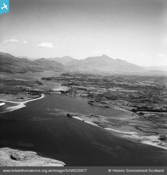
saw029877 SCOTLAND (1950). Loch Etive, general view, showing Connel Bridge and Ben Cruachan. An oblique aerial photograph taken facing east.
© Copyright OpenStreetMap contributors and licensed by the OpenStreetMap Foundation. 2025. Cartography is licensed as CC BY-SA.
Details
| Title | [SAW029877] Loch Etive, general view, showing Connel Bridge and Ben Cruachan. An oblique aerial photograph taken facing east. |
| Reference | SAW029877 |
| Date | 1950 |
| Link | Canmore Collection item 1269524 |
| Place name | |
| Parish | KILMORE AND KILBRIDE |
| District | ARGYLL AND BUTE |
| Country | SCOTLAND |
| Easting / Northing | 189620, 734280 |
| Longitude / Latitude | -5.4144300722979, 56.45373781413 |
| National Grid Reference | NM896343 |
Pins
 JMB |
Tuesday 14th of April 2015 12:10:49 PM | |
 Dunstaffnage |
Saturday 27th of October 2012 03:19:06 PM | |
 AJG |
Saturday 30th of June 2012 07:22:29 PM | |
 AJG |
Saturday 30th of June 2012 07:17:04 PM | |
The buildings are said to have originally been the officers' mess for RAF Connel. Oban Radio opened in 1949 but was initially in Nissen huts at the Southern edge the airfield (which had been bought by the GPO). They had an mobile emergency transmitter vehicle. They moved to the later site about two years later so this probably precedes that move |
 JMB |
Saturday 30th of June 2012 10:17:07 PM |
 Zebulon Vinge |
Monday 4th of June 2012 03:42:04 PM | |
 Zebulon Vinge |
Monday 4th of June 2012 03:40:40 PM |
User Comment Contributions
 Brian Wilkinson |
Friday 25th of May 2012 03:07:46 PM |


![[SAW029876] Loch Etive, general view, showing Connel Bridge and Ben Cruachan. An oblique aerial photograph taken facing east.](http://britainfromabove.org.uk/sites/all/libraries/aerofilms-images/public/100x100/SAW/029/SAW029876.jpg)
![[SAW029877] Loch Etive, general view, showing Connel Bridge and Ben Cruachan. An oblique aerial photograph taken facing east.](http://britainfromabove.org.uk/sites/all/libraries/aerofilms-images/public/100x100/SAW/029/SAW029877.jpg)
