
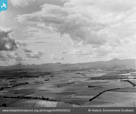
sar009013 SCOTLAND (1947). Vale of Forth, Drip Moss, Kincardine, Perthshire, Scotland, 1947. An oblique aerial photograph, taken facing north-west.
© Copyright OpenStreetMap contributors and licensed by the OpenStreetMap Foundation. 2026. Cartography is licensed as CC BY-SA.
Details
| Title | [SAR009013] Vale of Forth, Drip Moss, Kincardine, Perthshire, Scotland, 1947. An oblique aerial photograph, taken facing north-west. |
| Reference | SAR009013 |
| Date | 1947 |
| Link | NRHE Collection item 1452197 |
| Place name | |
| Parish | KINCARDINE (STIRLING) |
| District | STIRLING |
| Country | SCOTLAND |
| Easting / Northing | 275793, 695447 |
| Longitude / Latitude | -3.9988748868314, 56.135609406239 |
| National Grid Reference | NS758954 |
Pins

Grahame Lawson |
Monday 6th of October 2014 02:01:34 PM | |
|
ewnmcg |
Thursday 18th of September 2014 08:01:39 AM | |
 |
ewnmcg |
Wednesday 17th of September 2014 10:19:42 PM |
 |
ewnmcg |
Wednesday 17th of September 2014 09:45:17 PM |
 |
ewnmcg |
Wednesday 17th of September 2014 09:30:39 PM |
|
ewnmcg |
Wednesday 17th of September 2014 09:14:17 PM | |
|
ewnmcg |
Wednesday 17th of September 2014 09:13:44 PM | |
|
ewnmcg |
Wednesday 17th of September 2014 08:59:35 PM | |
|
ewnmcg |
Wednesday 17th of September 2014 08:49:00 PM |
User Comment Contributions
Thanks for all the helpful pins and comments on this image. We'll update the catalogue and post the new record here in due course. Yours, Connor Digitisation and Cataloguing Assistant, Britain from Above |

Connor Heaney |
Wednesday 1st of October 2014 04:30:22 PM |
In 1977 I was on my way to the Highlands up the A84 out of Stirling when I got as far as the junction with the A873 which is just to the north of this picture. My car died on me with no electrics so I just had to stop as it was getting dark. I was camping so I fly camped by the roadside and turned round the next morning to go back to see an auto electrician in Stirling and I had a new voltage regulator fitted.It was around the third week in September. The next day when I got to Glencoe it was snowing so I had to camp in the snow. So much for a late summer holiday! |

Class31 |
Monday 22nd of September 2014 01:57:47 PM |
I've just put the marker at the corner of Ochtertyre Wood as suggested by ewnmcg I agree with this location. |
Class31 |
Monday 22nd of September 2014 01:48:33 PM |
A good description for this image might be: Looking north-west across Flanders Moss in Stirlingshire, Scotland. The large Ochtertyre Moss Wood is on the right, with Ben Ledi above it in the distance. Last bit of info’ on this image is its location and, for this, I have chosen the approx. centre of Ochtertyre Moss Wood, i.e. the wooded large letter E shape on the right. National Grid Reference: NS 741 968. Latitude: 56.1472°N, Longitude: 4.028°W. |
ewnmcg |
Thursday 18th of September 2014 08:02:46 AM |