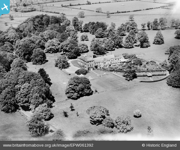
epw061392 ENGLAND (1939). Southill House, Cranmore, 1939
© Copyright OpenStreetMap contributors and licensed by the OpenStreetMap Foundation. 2025. Cartography is licensed as CC BY-SA.
Nearby Images (5)
Details
| Title | [EPW061392] Southill House, Cranmore, 1939 |
| Reference | EPW061392 |
| Date | 4-June-1939 |
| Link | |
| Place name | CRANMORE |
| Parish | CRANMORE |
| District | |
| Country | ENGLAND |
| Easting / Northing | 367184, 142621 |
| Longitude / Latitude | -2.4695457452284, 51.181357294774 |
| National Grid Reference | ST672426 |
Pins
 Class31 |
Monday 21st of July 2014 02:40:21 PM |


![[EPW061392] Southill House, Cranmore, 1939](http://britainfromabove.org.uk/sites/all/libraries/aerofilms-images/public/100x100/EPW/061/EPW061392.jpg)
![[EPW061394] Southill House, Cranmore, 1939](http://britainfromabove.org.uk/sites/all/libraries/aerofilms-images/public/100x100/EPW/061/EPW061394.jpg)
![[EPW061391] Southill House, Cranmore, 1939](http://britainfromabove.org.uk/sites/all/libraries/aerofilms-images/public/100x100/EPW/061/EPW061391.jpg)
![[EPW061395] Southill House, Cranmore, 1939](http://britainfromabove.org.uk/sites/all/libraries/aerofilms-images/public/100x100/EPW/061/EPW061395.jpg)
![[EPW061393] Southill House, Cranmore, 1939](http://britainfromabove.org.uk/sites/all/libraries/aerofilms-images/public/100x100/EPW/061/EPW061393.jpg)