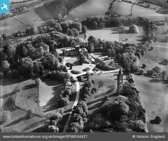
epw044427 ENGLAND (1934). Abberley Hall School and the Clock Tower, Abberley, 1934
© Copyright OpenStreetMap contributors and licensed by the OpenStreetMap Foundation. 2025. Cartography is licensed as CC BY-SA.
Nearby Images (9)
Details
| Title | [EPW044427] Abberley Hall School and the Clock Tower, Abberley, 1934 |
| Reference | EPW044427 |
| Date | May-1934 |
| Link | |
| Place name | ABBERLEY |
| Parish | ABBERLEY |
| District | |
| Country | ENGLAND |
| Easting / Northing | 374496, 266510 |
| Longitude / Latitude | -2.3740107022942, 52.295734590522 |
| National Grid Reference | SO745665 |
Pins
Be the first to add a comment to this image!


![[EPW044427] Abberley Hall School and the Clock Tower, Abberley, 1934](http://britainfromabove.org.uk/sites/all/libraries/aerofilms-images/public/100x100/EPW/044/EPW044427.jpg)
![[EPW044429] Abberley Hall School and the Clock Tower, Abberley, 1934](http://britainfromabove.org.uk/sites/all/libraries/aerofilms-images/public/100x100/EPW/044/EPW044429.jpg)
![[EPW044434] Abberley Hall School and the Clock Tower, Abberley, 1934](http://britainfromabove.org.uk/sites/all/libraries/aerofilms-images/public/100x100/EPW/044/EPW044434.jpg)
![[EPW044436] Abberley Hall School and the Clock Tower, Abberley, 1934](http://britainfromabove.org.uk/sites/all/libraries/aerofilms-images/public/100x100/EPW/044/EPW044436.jpg)
![[EPW044438] Abberley Hall School, the Clock Tower and environs, Abberley, 1934](http://britainfromabove.org.uk/sites/all/libraries/aerofilms-images/public/100x100/EPW/044/EPW044438.jpg)
![[EPW044431] Abberley Hall School and environs, Abberley, 1934](http://britainfromabove.org.uk/sites/all/libraries/aerofilms-images/public/100x100/EPW/044/EPW044431.jpg)
![[EPW044430] Abberley Hall School, Abberley, 1934](http://britainfromabove.org.uk/sites/all/libraries/aerofilms-images/public/100x100/EPW/044/EPW044430.jpg)
![[EPW044433] Abberley Hall School the Clock Tower and environs, Abberley, 1934](http://britainfromabove.org.uk/sites/all/libraries/aerofilms-images/public/100x100/EPW/044/EPW044433.jpg)
![[EPW044428] Abberley Hall School, Walled Garden, and the Clock Tower, Abberley, 1934](http://britainfromabove.org.uk/sites/all/libraries/aerofilms-images/public/100x100/EPW/044/EPW044428.jpg)