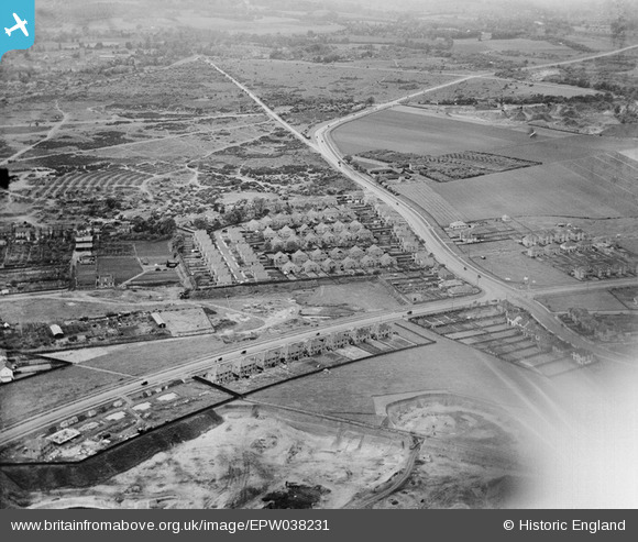
epw038231 ENGLAND (1932). Dartford Heath and new housing at Heathview Crescent and environs, Dartford, 1932
© Copyright OpenStreetMap contributors and licensed by the OpenStreetMap Foundation. 2024. Cartography is licensed as CC BY-SA.
Details
| Title | [EPW038231] Dartford Heath and new housing at Heathview Crescent and environs, Dartford, 1932 |
| Reference | EPW038231 |
| Date | June-1932 |
| Link | |
| Place name | DARTFORD |
| Parish | |
| District | |
| Country | ENGLAND |
| Easting / Northing | 552654, 173501 |
| Longitude / Latitude | 0.19664117545358, 51.439415281018 |
| National Grid Reference | TQ527735 |
Pins
 SirTricky |
Monday 28th of July 2014 10:45:05 AM | |
 SirTricky |
Friday 25th of July 2014 02:49:20 PM | |
 SirTricky |
Friday 25th of July 2014 02:39:14 PM | |
 SirTricky |
Friday 25th of July 2014 02:31:54 PM | |
 SirTricky |
Friday 25th of July 2014 02:30:52 PM | |
 SirTricky |
Friday 25th of July 2014 02:23:34 PM |


![[EPW038231] Dartford Heath and new housing at Heathview Crescent and environs, Dartford, 1932](http://britainfromabove.org.uk/sites/all/libraries/aerofilms-images/public/100x100/EPW/038/EPW038231.jpg)
![[EPW038232] Shepherd's Lane and new housing at Heathview Crescent and environs, Dartford, 1932](http://britainfromabove.org.uk/sites/all/libraries/aerofilms-images/public/100x100/EPW/038/EPW038232.jpg)
![[EPW038236] New housing at Heathview Crescent, Dartford, 1932](http://britainfromabove.org.uk/sites/all/libraries/aerofilms-images/public/100x100/EPW/038/EPW038236.jpg)
![[EPW038230] Shepherd's Lane and new housing at Heathview Crescent and environs, Dartford, 1932](http://britainfromabove.org.uk/sites/all/libraries/aerofilms-images/public/100x100/EPW/038/EPW038230.jpg)