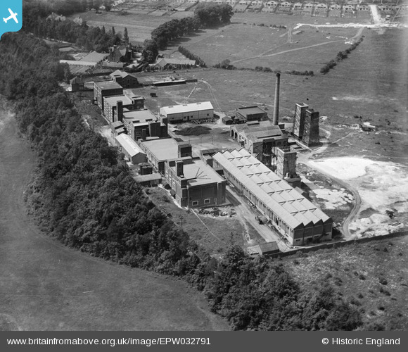
epw032791 ENGLAND (1930). Artificial Silk Works, Ashtead, 1930
© Copyright OpenStreetMap contributors and licensed by the OpenStreetMap Foundation. 2026. Cartography is licensed as CC BY-SA.
Nearby Images (11)
Details
| Title | [EPW032791] Artificial Silk Works, Ashtead, 1930 |
| Reference | EPW032791 |
| Date | June-1930 |
| Link | |
| Place name | ASHTEAD |
| Parish | |
| District | |
| Country | ENGLAND |
| Easting / Northing | 518396, 156677 |
| Longitude / Latitude | -0.30165792007074, 51.296387524492 |
| National Grid Reference | TQ184567 |
Pins
Be the first to add a comment to this image!
User Comment Contributions
Was it a production plant or a yarn processing plant? and what was the 'Artificial Silk'? Acetate or Viscose? What was the company? Anyone help? Dave Trigg. Derby. |

Triggy |
Friday 7th of February 2014 03:27:37 PM |
Was it a production plant or a yarn processing plant? and what was the 'Artificial Silk'? Acetate or Viscose? What was the company? Anyone help? Dave Trigg. Derby. |

Triggy |
Friday 7th of February 2014 03:23:35 PM |
This later became the Goblin vacuum cleaner factor (by the 1950's) using the same building. It is situated on Ermyn Way, a road that became a footpath leading from the west side of Ashtead towards Epsom Downs. It is now a modern office complex. The houses (bungalows) along the top edge of the image are on the A24. The area marked out for development (entrance road in place) is Stag Leys. Much of the space between the factory and the main road is now residential. |

Maurice |
Monday 7th of January 2013 08:03:28 AM |


![[EPW032791] Artificial Silk Works, Ashtead, 1930](http://britainfromabove.org.uk/sites/all/libraries/aerofilms-images/public/100x100/EPW/032/EPW032791.jpg)
![[EPW032790] Artificial Silk Works, Ashtead, 1930](http://britainfromabove.org.uk/sites/all/libraries/aerofilms-images/public/100x100/EPW/032/EPW032790.jpg)
![[EPW032787] Artificial Silk Works, Ashtead, 1930](http://britainfromabove.org.uk/sites/all/libraries/aerofilms-images/public/100x100/EPW/032/EPW032787.jpg)
![[EPW032789] Artificial Silk Works, Ashtead, 1930](http://britainfromabove.org.uk/sites/all/libraries/aerofilms-images/public/100x100/EPW/032/EPW032789.jpg)
![[EPW032792] Artificial Silk Works, Ashtead, 1930](http://britainfromabove.org.uk/sites/all/libraries/aerofilms-images/public/100x100/EPW/032/EPW032792.jpg)
![[EPW032793] Artificial Silk Works, Ashtead, 1930](http://britainfromabove.org.uk/sites/all/libraries/aerofilms-images/public/100x100/EPW/032/EPW032793.jpg)
![[EPW009813] The Artificial Silk Works beside Frederick Milner House, Ashstead, 1924. This image has been produced from a damaged negative.](http://britainfromabove.org.uk/sites/all/libraries/aerofilms-images/public/100x100/EPW/009/EPW009813.jpg)
![[EPW032788] Artificial Silk Works, Ashtead, 1930](http://britainfromabove.org.uk/sites/all/libraries/aerofilms-images/public/100x100/EPW/032/EPW032788.jpg)
![[EPW009813A] The Artificial Silk Works beside Frederick Milner House, Ashstead, 1924](http://britainfromabove.org.uk/sites/all/libraries/aerofilms-images/public/100x100/EPW/009/EPW009813A.jpg)
![[EPW025239] Industrial complex next to Long House, Ashtead, 1928. This image has been produced from a copy-negative.](http://britainfromabove.org.uk/sites/all/libraries/aerofilms-images/public/100x100/EPW/025/EPW025239.jpg)
![[EPW017558] Artificial Silk Works, Ashtead, 1927. This image was marked by Aerofilms Ltd for photo editing.](http://britainfromabove.org.uk/sites/all/libraries/aerofilms-images/public/100x100/EPW/017/EPW017558.jpg)