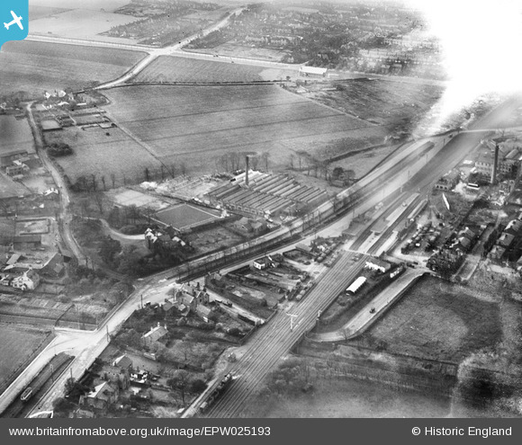
epw025193 ENGLAND (1928). The Cocoa Works, Broad Green, 1928
© Copyright OpenStreetMap contributors and licensed by the OpenStreetMap Foundation. 2025. Cartography is licensed as CC BY-SA.
Nearby Images (10)
Details
| Title | [EPW025193] The Cocoa Works, Broad Green, 1928 |
| Reference | EPW025193 |
| Date | 21-October-1928 |
| Link | |
| Place name | BROAD GREEN |
| Parish | |
| District | |
| Country | ENGLAND |
| Easting / Northing | 340740, 390249 |
| Longitude / Latitude | -2.8914926069059, 53.405467446232 |
| National Grid Reference | SJ407902 |
Pins
 1bcamden |
Saturday 7th of October 2023 03:36:59 AM | |
 1bcamden |
Saturday 7th of October 2023 03:35:53 AM | |
 1bcamden |
Saturday 7th of October 2023 03:35:19 AM | |
 1bcamden |
Saturday 7th of October 2023 03:01:42 AM | |
 1bcamden |
Saturday 7th of October 2023 02:42:15 AM | |
 1bcamden |
Saturday 7th of October 2023 02:39:51 AM | |
 John W |
Sunday 3rd of July 2016 08:58:43 PM | |
 John W |
Sunday 3rd of July 2016 08:57:42 PM | |
 Oldboy |
Friday 22nd of April 2016 10:38:49 PM | |
 Oldboy |
Friday 22nd of April 2016 10:34:32 PM | |
 Oldboy |
Friday 22nd of April 2016 01:25:25 PM | |
 Oldboy |
Friday 22nd of April 2016 01:22:42 PM | |
 Oldboy |
Friday 22nd of April 2016 01:18:13 PM | |
 Oldboy |
Friday 22nd of April 2016 12:03:47 PM | |
 Oldboy |
Friday 22nd of April 2016 12:01:56 PM | |
The section between the two roads is a 'reserved' tram lines area, carrying Liverpool Corporation trams between Liverpool and Roby. (See tram in lower left corner.) |
 John W |
Sunday 3rd of July 2016 09:00:34 PM |
 Oldboy |
Friday 22nd of April 2016 10:24:37 AM | |
 Oldboy |
Friday 22nd of April 2016 10:21:52 AM | |
 Oldboy |
Friday 22nd of April 2016 10:14:05 AM | |
 Oldboy |
Friday 22nd of April 2016 10:11:33 AM | |
 Oldboy |
Friday 22nd of April 2016 10:10:41 AM | |
 Strider |
Sunday 17th of August 2014 08:42:04 PM | |
 Strider |
Sunday 17th of August 2014 08:39:32 PM | |
 Strider |
Sunday 17th of August 2014 08:38:22 PM |


![[EPW025193] The Cocoa Works, Broad Green, 1928](http://britainfromabove.org.uk/sites/all/libraries/aerofilms-images/public/100x100/EPW/025/EPW025193.jpg)
![[EPW025195] The Cocoa Works and BRITO Margarine Works, Broad Green, 1928](http://britainfromabove.org.uk/sites/all/libraries/aerofilms-images/public/100x100/EPW/025/EPW025195.jpg)
![[EPW025194] The Cocoa Works and BRITO Margarine Works, Broad Green, 1928](http://britainfromabove.org.uk/sites/all/libraries/aerofilms-images/public/100x100/EPW/025/EPW025194.jpg)
![[EPW025342] Cocoa Works and Broad Green Station, Broad Green, 1928](http://britainfromabove.org.uk/sites/all/libraries/aerofilms-images/public/100x100/EPW/025/EPW025342.jpg)
![[EPW025344] Cocoa Works and Margarine Works, Broad Green, 1928](http://britainfromabove.org.uk/sites/all/libraries/aerofilms-images/public/100x100/EPW/025/EPW025344.jpg)
![[EPW025196] The Cocoa Works, Broad Green, 1928](http://britainfromabove.org.uk/sites/all/libraries/aerofilms-images/public/100x100/EPW/025/EPW025196.jpg)
![[EPW025343] Cocoa Works off Broad Green Road, Broad Green, 1928](http://britainfromabove.org.uk/sites/all/libraries/aerofilms-images/public/100x100/EPW/025/EPW025343.jpg)
![[EPW025341] Cocoa Works and Broad Green Station, Broad Green, 1928](http://britainfromabove.org.uk/sites/all/libraries/aerofilms-images/public/100x100/EPW/025/EPW025341.jpg)
![[EPW025340] Cocoa Works and Broad Green Hall, Broad Green, 1928](http://britainfromabove.org.uk/sites/all/libraries/aerofilms-images/public/100x100/EPW/025/EPW025340.jpg)
![[EPW025192] The Cocoa Works, Broad Green, 1928](http://britainfromabove.org.uk/sites/all/libraries/aerofilms-images/public/100x100/EPW/025/EPW025192.jpg)