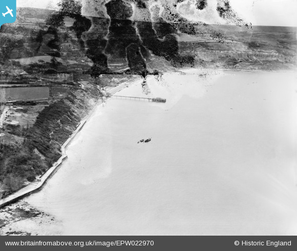
epw022970 ENGLAND (1928). Totland Bay, Totland, from the north, 1928
© Copyright OpenStreetMap contributors and licensed by the OpenStreetMap Foundation. 2024. Cartography is licensed as CC BY-SA.
Details
| Title | [EPW022970] Totland Bay, Totland, from the north, 1928 |
| Reference | EPW022970 |
| Date | August-1928 |
| Link | |
| Place name | TOTLAND |
| Parish | TOTLAND |
| District | |
| Country | ENGLAND |
| Easting / Northing | 432271, 87462 |
| Longitude / Latitude | -1.543138124282, 50.685338452654 |
| National Grid Reference | SZ323875 |
Pins
 HALLY64 |
Thursday 8th of August 2013 03:05:36 PM | |
 HALLY64 |
Thursday 8th of August 2013 03:02:03 PM | |
 HALLY64 |
Thursday 8th of August 2013 02:58:31 PM | |
 HALLY64 |
Thursday 8th of August 2013 02:57:22 PM | |
 HALLY64 |
Thursday 8th of August 2013 02:56:10 PM | |
 HALLY64 |
Thursday 8th of August 2013 02:53:44 PM |


![[EPW022970] Totland Bay, Totland, from the north, 1928](http://britainfromabove.org.uk/sites/all/libraries/aerofilms-images/public/100x100/EPW/022/EPW022970.jpg)
![[EAW038613] Totland Pier and Colwell Bay, Totland, from the south-west, 1951. This image has been produced from a damaged negative.](http://britainfromabove.org.uk/sites/all/libraries/aerofilms-images/public/100x100/EAW/038/EAW038613.jpg)

.jpg?itok=jvC7fRvU)
.jpg?itok=J1Vuhr5W)