
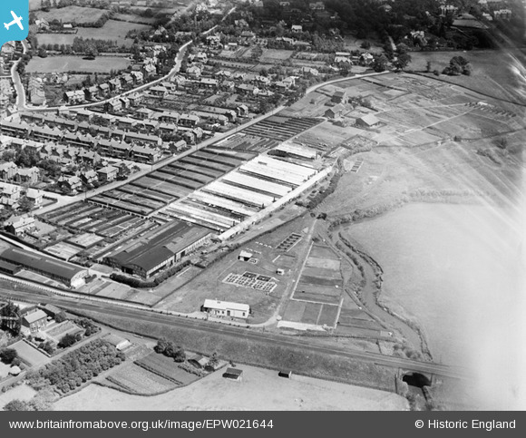
epw021644 ENGLAND (1928). Clibrans Nursery and the Hale Sewage Works off Bankhall Lane, Hale, 1928
© Copyright OpenStreetMap contributors and licensed by the OpenStreetMap Foundation. 2026. Cartography is licensed as CC BY-SA.
Nearby Images (2)
EPW021644

EPW021643

Details
| Title | [EPW021644] Clibrans Nursery and the Hale Sewage Works off Bankhall Lane, Hale, 1928 |
| Reference | EPW021644 |
| Date | June-1928 |
| Link | |
| Place name | HALE |
| Parish | |
| District | |
| Country | ENGLAND |
| Easting / Northing | 377411, 385733 |
| Longitude / Latitude | -2.3395193835367, 53.367715043505 |
| National Grid Reference | SJ774857 |
Pins

John Ellis |
Tuesday 21st of October 2014 02:49:17 PM | |
|
John Ellis |
Tuesday 21st of October 2014 02:48:15 PM | |
|
John Ellis |
Tuesday 21st of October 2014 02:46:44 PM | |
|
John Ellis |
Tuesday 21st of October 2014 02:45:53 PM | |
|
John Ellis |
Tuesday 21st of October 2014 02:45:01 PM | |
|
John Ellis |
Tuesday 21st of October 2014 02:41:13 PM | |
|
John Ellis |
Tuesday 21st of October 2014 02:39:14 PM | |
|
John Ellis |
Tuesday 21st of October 2014 02:38:47 PM | |
|
John Ellis |
Tuesday 21st of October 2014 02:36:44 PM | |
|
John Ellis |
Tuesday 21st of October 2014 02:35:34 PM | |
|
John Ellis |
Tuesday 21st of October 2014 02:33:53 PM | |
|
John Ellis |
Tuesday 21st of October 2014 02:33:13 PM | |
|
John Ellis |
Tuesday 21st of October 2014 02:32:36 PM | |
|
John Ellis |
Tuesday 21st of October 2014 11:50:31 AM | |
|
John Ellis |
Tuesday 21st of October 2014 11:48:25 AM |