
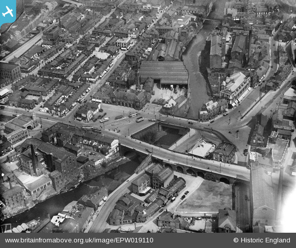
epw019110 ENGLAND (1927). Wellington Bridge and Mersey Bridge, Stockport, 1927
© Copyright OpenStreetMap contributors and licensed by the OpenStreetMap Foundation. 2026. Cartography is licensed as CC BY-SA.
Nearby Images (4)
EPW019110

EPW036820

EPW013108

EPW013110

Details
| Title | [EPW019110] Wellington Bridge and Mersey Bridge, Stockport, 1927 |
| Reference | EPW019110 |
| Date | 4-August-1927 |
| Link | |
| Place name | STOCKPORT |
| Parish | |
| District | |
| Country | ENGLAND |
| Easting / Northing | 389306, 390358 |
| Longitude / Latitude | -2.1608918910413, 53.409666526628 |
| National Grid Reference | SJ893904 |
Pins

Ford |
Thursday 11th of June 2026 02:44:53 PM | |

Billy Turner |
Wednesday 9th of December 2015 07:12:08 PM | |
Talbot Sunbeam Darracq on the roof, although the merged companies were known as Sunbeam Talbot Darracq, or STD Motors |
pfg |
Saturday 16th of July 2016 12:21:27 AM |
|
ianscarb |
Friday 28th of February 2014 06:46:11 PM | |
|
John Ellis |
Thursday 15th of November 2012 08:57:15 PM | |
|
totoro |
Monday 23rd of July 2012 10:05:29 PM | |
|
totoro |
Monday 23rd of July 2012 10:03:29 PM | |
|
totoro |
Monday 23rd of July 2012 10:02:31 PM | |
|
totoro |
Monday 23rd of July 2012 10:01:06 PM | |
Before the shopping center was built it was a road (Merseyway)regarded at the time as quite an engineering feat. I lived in Stockport in the 1940's and remember being fascinated by the river under the road. |
Keith |
Wednesday 12th of November 2014 07:57:24 PM |
|
totoro |
Monday 23rd of July 2012 09:56:16 PM | |
|
robertcollister |
Monday 2nd of July 2012 02:05:16 PM | |
|
JB |
Tuesday 26th of June 2012 01:07:27 AM | |
Built in 1932- in this photo still the old cottages |
totoro |
Sunday 1st of July 2012 09:03:27 PM |
The site of the Plaza is to the left of the pin location, where the cottages are. The Plaza building replaced the cottages in 1932, and was also partly built into a newly excavated cavern. |
totoro |
Sunday 1st of July 2012 09:06:03 PM |
|
totoro |
Friday 22nd of June 2012 02:27:48 PM | |
|
totoro |
Friday 22nd of June 2012 02:25:48 PM | |
|
totoro |
Friday 22nd of June 2012 02:23:55 PM | |
|
totoro |
Friday 22nd of June 2012 02:22:43 PM | |
The railway line was not built over by the motorway - however it was closed when construction of the motorway caused a collapse within the tunnel that runs through the sandstone to the side of the motorway cutting. It is only in the past 20 years or so that the viaduct that ran alongside the motorway from the tunnel entrance at Lancashire Hill, across the Tesco car park and over Tiviot Way and behind the Thomas Storey site now "Spark Industrial Estate) was demolished. |
xfield |
Thursday 23rd of May 2013 10:43:25 PM |
|
totoro |
Friday 22nd of June 2012 02:20:01 PM | |
|
totoro |
Friday 22nd of June 2012 02:19:27 PM | |
|
totoro |
Friday 22nd of June 2012 02:15:31 PM | |
|
totoro |
Friday 22nd of June 2012 02:14:14 PM | |
|
totoro |
Friday 22nd of June 2012 02:13:38 PM | |
|
totoro |
Friday 22nd of June 2012 02:11:38 PM |

User Comment Contributions
VFine photograph:I used to walk down steps from A6 to archway below every schoolday to catch 2nd bus(of3) home from Stockport Grammar School(1966-70) to Cheadle thence to get home near top of School's Hill |
roger freeman |
Sunday 2nd of December 2012 08:04:23 PM |
This area has changed a lot- the area between Mersey Bridge and Wellington Bridge is now Mersey Square, the river has been covered over beyond Mersey Bridge to form a shopping centre and the building below and to the right of the river are now a bus station. |
totoro |
Friday 22nd of June 2012 02:13:17 PM |