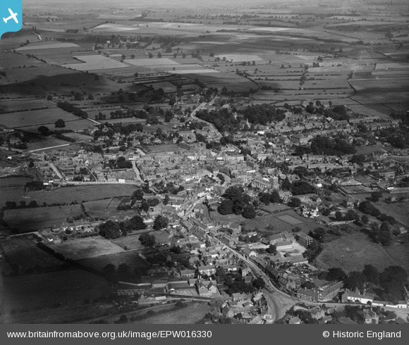
epw016330 ENGLAND (1926). View of the town, Horncastle, from the north-west, 1926
© Copyright OpenStreetMap contributors and licensed by the OpenStreetMap Foundation. 2025. Cartography is licensed as CC BY-SA.
Details
| Title | [EPW016330] View of the town, Horncastle, from the north-west, 1926 |
| Reference | EPW016330 |
| Date | July-1926 |
| Link | |
| Place name | HORNCASTLE |
| Parish | HORNCASTLE |
| District | |
| Country | ENGLAND |
| Easting / Northing | 525644, 369661 |
| Longitude / Latitude | -0.11843284511858, 53.208859464619 |
| National Grid Reference | TF256697 |
Pins
 Neil M |
Friday 19th of February 2016 09:59:20 AM | |
 John Stephenson |
Friday 21st of June 2013 09:08:52 PM | |
High Toynton was one of 53 villages in England and Wales , known as "Thankful Villages" - no men were lost in WW1 because all who left to serve came home again. |
Lynda Tubbs |
Wednesday 2nd of April 2014 02:27:49 PM |
 John Stephenson |
Friday 21st of June 2013 09:04:28 PM | |
 John Stephenson |
Friday 21st of June 2013 09:01:49 PM | |
 John Stephenson |
Friday 21st of June 2013 09:01:02 PM | |
 John Stephenson |
Friday 21st of June 2013 08:56:48 PM | |
 John Stephenson |
Friday 21st of June 2013 08:55:24 PM | |
 John Stephenson |
Friday 21st of June 2013 08:53:48 PM | |
 John Stephenson |
Friday 21st of June 2013 05:52:35 PM | |
 John Stephenson |
Friday 21st of June 2013 05:50:53 PM | |
 John Stephenson |
Friday 21st of June 2013 05:49:10 PM | |
 John Stephenson |
Friday 21st of June 2013 05:48:14 PM | |
 John Stephenson |
Friday 21st of June 2013 05:47:08 PM | |
 John Stephenson |
Friday 21st of June 2013 05:46:30 PM | |
 John Stephenson |
Friday 21st of June 2013 05:38:44 PM | |
 John Stephenson |
Friday 21st of June 2013 05:36:02 PM | |
 zspring |
Monday 26th of November 2012 02:19:27 PM | |
 zspring |
Monday 26th of November 2012 02:15:49 PM | |
 kent |
Wednesday 18th of July 2012 08:24:45 AM | |
 kent |
Wednesday 18th of July 2012 08:23:38 AM | |
 kent |
Wednesday 18th of July 2012 08:21:59 AM | |
 kent |
Wednesday 18th of July 2012 08:20:16 AM | |
 kent |
Wednesday 18th of July 2012 08:02:55 AM | |
 kent |
Wednesday 18th of July 2012 07:57:48 AM |


![[EPW016330] View of the town, Horncastle, from the north-west, 1926](http://britainfromabove.org.uk/sites/all/libraries/aerofilms-images/public/100x100/EPW/016/EPW016330.jpg)
![[EPW016331] View of the town, Horncastle, from the west, 1926](http://britainfromabove.org.uk/sites/all/libraries/aerofilms-images/public/100x100/EPW/016/EPW016331.jpg)