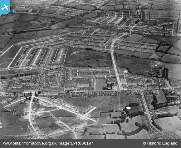
epr000197 ENGLAND (1934). The Tithe Farm Housing Estate under construction, South Harrow, 1934
© Copyright OpenStreetMap contributors and licensed by the OpenStreetMap Foundation. 2024. Cartography is licensed as CC BY-SA.
Details
| Title | [EPR000197] The Tithe Farm Housing Estate under construction, South Harrow, 1934 |
| Reference | EPR000197 |
| Date | 17-July-1934 |
| Link | |
| Place name | SOUTH HARROW |
| Parish | |
| District | |
| Country | ENGLAND |
| Easting / Northing | 513051, 186516 |
| Longitude / Latitude | -0.3687694970874, 51.565696516278 |
| National Grid Reference | TQ131865 |
Pins
 Roy Cousins |
Thursday 2nd of April 2015 03:39:24 PM | |
 Roy Cousins |
Thursday 2nd of April 2015 03:37:42 PM | |
 Roy Cousins |
Thursday 2nd of April 2015 03:36:17 PM | |
 Roy Cousins |
Thursday 2nd of April 2015 03:34:47 PM | |
 Roy Cousins |
Thursday 2nd of April 2015 03:33:13 PM | |
 Roy Cousins |
Thursday 2nd of April 2015 03:31:42 PM |


![[EPR000197] The Tithe Farm Housing Estate under construction, South Harrow, 1934](http://britainfromabove.org.uk/sites/all/libraries/aerofilms-images/public/100x100/EPR/000/EPR000197.jpg)
![[EPR000198] The Tithe Farm Housing Estate, South Harrow, 1934](http://britainfromabove.org.uk/sites/all/libraries/aerofilms-images/public/100x100/EPR/000/EPR000198.jpg)
![[EPR000200A] The Tithe Farm Housing Estate, South Harrow, 1934](http://britainfromabove.org.uk/sites/all/libraries/aerofilms-images/public/100x100/EPR/000/EPR000200A.jpg)