
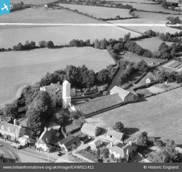
eaw011411 ENGLAND (1947). Horsebridge Flour Mill, Upper Horsebridge, 1947. This image was marked by Aerofilms Ltd for photo editing.
© Copyright OpenStreetMap contributors and licensed by the OpenStreetMap Foundation. 2026. Cartography is licensed as CC BY-SA.
Nearby Images (8)
EAW011411

EAW011412

EAW011408

EAW011405

EAW011409

EAW011406

EAW011410

EAW011407

Details
| Title | [EAW011411] Horsebridge Flour Mill, Upper Horsebridge, 1947. This image was marked by Aerofilms Ltd for photo editing. |
| Reference | EAW011411 |
| Date | 1-October-1947 |
| Link | |
| Place name | UPPER HORSEBRIDGE |
| Parish | HAILSHAM |
| District | |
| Country | ENGLAND |
| Easting / Northing | 558120, 111367 |
| Longitude / Latitude | 0.24791711661711, 50.879578349038 |
| National Grid Reference | TQ581114 |
Pins

John Cockcroft |
Sunday 7th of September 2025 04:15:59 PM | |

bescotbeast |
Thursday 15th of October 2015 04:13:32 PM | |
|
bescotbeast |
Thursday 15th of October 2015 04:13:00 PM | |
|
MB |
Sunday 24th of November 2013 10:28:14 AM | |
|
MB |
Sunday 24th of November 2013 10:27:02 AM | |
|
MB |
Sunday 24th of November 2013 10:26:21 AM |
User Comment Contributions
The mill was built in 1884; the previous structure was destroyed in a fire reported in the Sussex Advertiser, 30-9-1884. In the early twentieth century a two-sack roller plant was installed. A further fire in 1908 caused damage to the plant. Waterpower was used until 1945; a steam engine was used sparingly. After 1945 the mill relied on electricity. The low breastshot waterwheel of 17ft diam. x 8ft 10in width was still in situ in the 1990s. [Source: Derek Stidder & Colin Smith, Watermills of Sussex. Volume I - East Sussex. Baron Birch 1997] |
MB |
Sunday 24th of November 2013 10:46:54 AM |