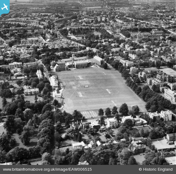
eaw006515 ENGLAND (1947). Cheltenham College and Playing Fields, Cheltenham, 1947
© Copyright OpenStreetMap contributors and licensed by the OpenStreetMap Foundation. 2025. Cartography is licensed as CC BY-SA.
Nearby Images (15)
Details
| Title | [EAW006515] Cheltenham College and Playing Fields, Cheltenham, 1947 |
| Reference | EAW006515 |
| Date | 31-May-1947 |
| Link | |
| Place name | CHELTENHAM |
| Parish | |
| District | |
| Country | ENGLAND |
| Easting / Northing | 395043, 221405 |
| Longitude / Latitude | -2.0720379647513, 51.890738697869 |
| National Grid Reference | SO950214 |
Pins
 Richard |
Wednesday 11th of June 2014 10:49:16 PM | |
 Richard |
Wednesday 11th of June 2014 10:48:03 PM | |
 Richard |
Wednesday 11th of June 2014 10:47:08 PM | |
 Richard |
Wednesday 11th of June 2014 10:46:17 PM | |
 Richard |
Wednesday 11th of June 2014 10:44:32 PM | |
 Richard |
Wednesday 11th of June 2014 10:43:12 PM | |
 Richard |
Wednesday 11th of June 2014 10:39:39 PM |
User Comment Contributions
Cheltenham College |
 Class31 |
Monday 11th of November 2013 12:47:16 PM |
Cheltenham College |
 Class31 |
Monday 11th of November 2013 12:46:19 PM |
Cheltenham College |
 Class31 |
Monday 11th of November 2013 12:45:08 PM |
Cheltenham College |
 Class31 |
Monday 11th of November 2013 12:44:04 PM |
Cheltenham College |
 Class31 |
Monday 11th of November 2013 12:43:11 PM |
Cheltenham College |
 Class31 |
Monday 11th of November 2013 12:35:06 PM |


![[EAW006515] Cheltenham College and Playing Fields, Cheltenham, 1947](http://britainfromabove.org.uk/sites/all/libraries/aerofilms-images/public/100x100/EAW/006/EAW006515.jpg)
![[EPR000385] Cheltenham College, Cheltenham, 1934. This image was marked by Aero Pictorial Ltd for photo editing.](http://britainfromabove.org.uk/sites/all/libraries/aerofilms-images/public/100x100/EPR/000/EPR000385.jpg)
![[EPW024137] Cheltenham College, Cheltenham, 1928](http://britainfromabove.org.uk/sites/all/libraries/aerofilms-images/public/100x100/EPW/024/EPW024137.jpg)
![[EPW048208] Cheltenham College and the town, Cheltenham, 1935](http://britainfromabove.org.uk/sites/all/libraries/aerofilms-images/public/100x100/EPW/048/EPW048208.jpg)
![[EPW048207] Cheltenham College and the town, Cheltenham, 1935](http://britainfromabove.org.uk/sites/all/libraries/aerofilms-images/public/100x100/EPW/048/EPW048207.jpg)
![[EAW006516] Cheltenham College and Playing Fields, Cheltenham, 1947](http://britainfromabove.org.uk/sites/all/libraries/aerofilms-images/public/100x100/EAW/006/EAW006516.jpg)
![[EPW000175] Cheltenham College, Cheltenham, 1920](http://britainfromabove.org.uk/sites/all/libraries/aerofilms-images/public/100x100/EPW/000/EPW000175.jpg)
![[EPW000174] Cheltenham College, Cheltenham, 1920](http://britainfromabove.org.uk/sites/all/libraries/aerofilms-images/public/100x100/EPW/000/EPW000174.jpg)
![[EPW024139] Cheltenham College, Cheltenham, 1928](http://britainfromabove.org.uk/sites/all/libraries/aerofilms-images/public/100x100/EPW/024/EPW024139.jpg)
![[EPW024138] Cheltenham College, Cheltenham, 1928](http://britainfromabove.org.uk/sites/all/libraries/aerofilms-images/public/100x100/EPW/024/EPW024138.jpg)
![[EAW006523] Cheltenham College, Cheltenham, 1947](http://britainfromabove.org.uk/sites/all/libraries/aerofilms-images/public/100x100/EAW/006/EAW006523.jpg)
![[EPW000178] Cheltenham College, Cheltenham, 1920](http://britainfromabove.org.uk/sites/all/libraries/aerofilms-images/public/100x100/EPW/000/EPW000178.jpg)
![[EPW048199] The open air swimming pool (Sandford Parks Lido), Cheltenham, 1935](http://britainfromabove.org.uk/sites/all/libraries/aerofilms-images/public/100x100/EPW/048/EPW048199.jpg)
![[EPW048198] The open air swimming pool (Sandford Parks Lido), Cheltenham, 1935](http://britainfromabove.org.uk/sites/all/libraries/aerofilms-images/public/100x100/EPW/048/EPW048198.jpg)
![[EAW006518] Crowds at Sandford Swimming Pool, Cheltenham, 1947](http://britainfromabove.org.uk/sites/all/libraries/aerofilms-images/public/100x100/EAW/006/EAW006518.jpg)