
XPW043543 IRELAND (1933). Nenagh Reservoir, Nenagh, Carlow, Ireland, 1933. Oblique aerial photograph taken facing South/West.
© Copyright OpenStreetMap contributors and licensed by the OpenStreetMap Foundation. 2025. Cartography is licensed as CC BY-SA.
Nearby Images (5)
XPW043543

XPW043556

XPW043555

XPW043554

XPW043553

Details
| Title | [XPW043543] Nenagh Reservoir, Nenagh, Carlow, Ireland, 1933. Oblique aerial photograph taken facing South/West. |
| Reference | XPW043543 |
| Date | 1933 |
| Link | |
| Place name | NENAGH |
| Parish | IRELAND |
| District | |
| Country | IRELAND |
| Easting / Northing | 68200, 337991 |
| Longitude / Latitude | -6.92849, 52.836945 |
| National Grid Reference |
Pins
Be the first to add a comment to this image!
User Comment Contributions
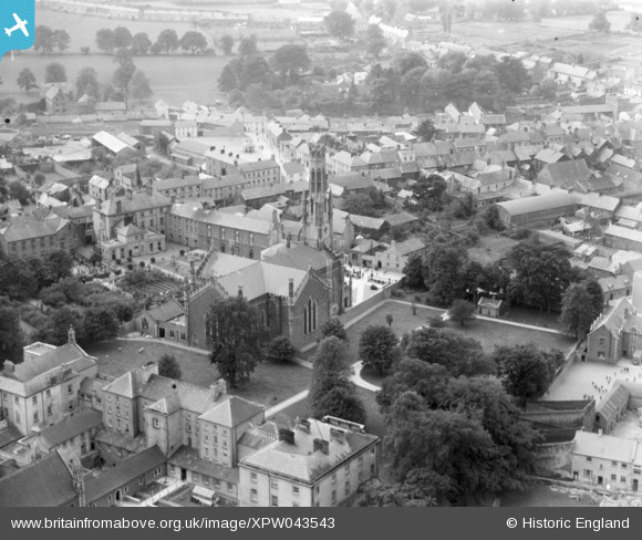
This is a photo of Carlow Cathedral taken just over a century since work began on the building in 1829, the same year that the Catholic Emancipation Act was passed. The granite church was designed by Thomas Cobden, in early Neo-Gothic style, with a distinctive octagonal tower 46 metres high. The lantern-shaped tower, finished with turrets and crenulations, is reminiscent of the Cloth Hall, Bruges, Belgium. This splendid feature, coupled with the judicious use of granite ashlar in the octagonal turrets at the terminal ends of the nave and transepts, masks the fact that the main body of the cathedral was built with dark limestone. Carlow is the county town and main urban centre of the northern part of Co.Carlow, with a population of 7,642 in the 1936 Census. The city has good road and rail links to the capital, in addition to being situated on the Barrow Navigation system. The urban area of Carlow had a population exceeding 13,000 in 2002. |
 John Swain |
Saturday 11th of October 2014 12:14:33 PM |