
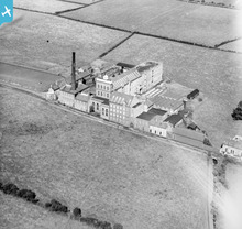
XPW028713 NORTHERN IRELAND (1929). General View, Carrickfergus, Carrickfergus, Northern Ireland, 1929. Oblique aerial photograph taken facing North/East.

© Copyright OpenStreetMap contributors and licensed by the OpenStreetMap Foundation. 2026. Cartography is licensed as CC BY-SA.
Nearby Images (2)
XPW028713

XPW028712

Details
| Title | [XPW028713] General View, Carrickfergus, Carrickfergus, Northern Ireland, 1929. Oblique aerial photograph taken facing North/East. |
| Reference | XPW028713 |
| Date | 1929 |
| Link | |
| Place name | CARRICKFERGUS |
| Parish | NORTHERN IRELAND |
| District | |
| Country | NORTHERN IRELAND |
| Easting / Northing | 155460, 543104 |
| Longitude / Latitude | -5.799052, 54.723307 |
| National Grid Reference |
Pins
Be the first to add a comment to this image!
User Comment Contributions
Barn Mills 1929 |

Valerie |
Monday 13th of October 2014 11:04:49 PM |