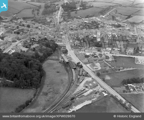
XPW028670 NORTHERN IRELAND (1929). General View, Downpatrick, Down, Northern Ireland, 1929. Oblique aerial photograph taken facing East.
© Copyright OpenStreetMap contributors and licensed by the OpenStreetMap Foundation. 2026. Cartography is licensed as CC BY-SA.
Details
| Title | [XPW028670] General View, Downpatrick, Down, Northern Ireland, 1929. Oblique aerial photograph taken facing East. |
| Reference | XPW028670 |
| Date | 1929 |
| Link | |
| Place name | DOWNPATRICK |
| Parish | NORTHERN IRELAND |
| District | |
| Country | NORTHERN IRELAND |
| Easting / Northing | 158268, 498707 |
| Longitude / Latitude | -5.719134, 54.326519 |
| National Grid Reference |
Pins

Milepost98 |
Wednesday 4th of July 2018 11:22:39 PM | |

Milepost98 |
Friday 27th of February 2015 10:34:27 PM | |

john little |
Wednesday 15th of October 2014 11:26:52 PM | |

john little |
Wednesday 15th of October 2014 11:26:06 PM | |

john little |
Wednesday 15th of October 2014 11:16:33 PM | |
This was the turntable. |

Buzby |
Monday 3rd of November 2014 08:08:03 PM |

MB |
Monday 6th of October 2014 04:56:51 PM | |

MB |
Monday 6th of October 2014 04:55:51 PM | |

MB |
Monday 6th of October 2014 04:54:20 PM | |

MB |
Monday 6th of October 2014 04:52:52 PM | |
You are correct, a 4-4-2 Tank Engine |

Buzby |
Monday 3rd of November 2014 08:09:59 PM |

Class31 |
Monday 6th of October 2014 04:29:19 PM | |

Class31 |
Monday 6th of October 2014 04:26:36 PM |


![[XPW028670] General View, Downpatrick, Down, Northern Ireland, 1929. Oblique aerial photograph taken facing East.](http://britainfromabove.org.uk/sites/all/libraries/aerofilms-images/public/100x100/XPW/028/XPW028670.jpg)
![[XPW028667] General Views With Church, Downpatrick, Down, Northern Ireland, 1929. Oblique aerial photograph taken facing East.](http://britainfromabove.org.uk/sites/all/libraries/aerofilms-images/public/100x100/XPW/028/XPW028667.jpg)
![[XPW028671] General View, Downpatrick, Down, Northern Ireland, 1929. Oblique aerial photograph taken facing North.](http://britainfromabove.org.uk/sites/all/libraries/aerofilms-images/public/100x100/XPW/028/XPW028671.jpg)