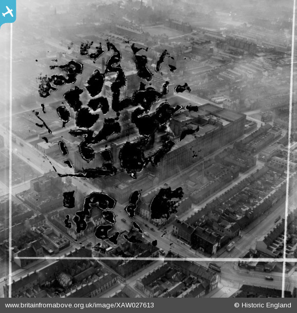
XAW027613 NORTHERN IRELAND (1949). Gallaher Ltd., Virginia House, 1 Skelford Street, E.C.1. Factory at York Street, Belfast, Belfast, Belfast, Northern Ireland, 1949. Oblique aerial photograph taken facing South. This image was marked by Aerofilms Ltd for photo editing and has
© Copyright OpenStreetMap contributors and licensed by the OpenStreetMap Foundation. 2026. Cartography is licensed as CC BY-SA.
Nearby Images (12)
Details
| Title | [XAW027613] Gallaher Ltd., Virginia House, 1 Skelford Street, E.C.1. Factory at York Street, Belfast, Belfast, Belfast, Northern Ireland, 1949. Oblique aerial photograph taken facing South. This image was marked by Aerofilms Ltd for photo editing and has |
| Reference | XAW027613 |
| Date | 2-November-1949 |
| Link | |
| Place name | BELFAST |
| Parish | NORTHERN IRELAND |
| District | |
| Country | NORTHERN IRELAND |
| Easting / Northing | 146608, 530962 |
| Longitude / Latitude | -5.925641, 54.610063 |
| National Grid Reference |
Pins

John Wass |
Sunday 28th of September 2014 04:01:45 PM |


![[XAW027613] Gallaher Ltd., Virginia House, 1 Skelford Street,
E.C.1. Factory at York Street, Belfast, Belfast, Belfast, Northern Ireland, 1949. Oblique aerial photograph taken facing South. This image was marked by Aerofilms Ltd for photo editing and has](http://britainfromabove.org.uk/sites/all/libraries/aerofilms-images/public/100x100/XAW/027/XAW027613.jpg)
![[XAW027608] Virginia House, Belfast, Belfast, Northern Ireland, 1949. Oblique aerial photograph taken facing South. This image was marked by Aerofilms Ltd for photo editing.](http://britainfromabove.org.uk/sites/all/libraries/aerofilms-images/public/100x100/XAW/027/XAW027608.jpg)
![[XPW033869] Gallahers Ltd, Belfast, Belfast, Northern Ireland, 1930. Oblique aerial photograph taken facing North.](http://britainfromabove.org.uk/sites/all/libraries/aerofilms-images/public/100x100/XPW/033/XPW033869.jpg)
![[XAW027614] Gallaher Ltd., Virginia House E.C., Belfast, Belfast, Northern Ireland, 1949. Oblique aerial photograph taken facing North/East. This image was marked by Aerofilms Ltd for photo editing.](http://britainfromabove.org.uk/sites/all/libraries/aerofilms-images/public/100x100/XAW/027/XAW027614.jpg)
![[XPW033875] Gallahers, Belfast, Belfast, Northern Ireland, 1930. Oblique aerial photograph taken facing North.](http://britainfromabove.org.uk/sites/all/libraries/aerofilms-images/public/100x100/XPW/033/XPW033875.jpg)
![[XPW033870] General View, Belfast, Belfast, Northern Ireland, 1929. Oblique aerial photograph taken facing North.](http://britainfromabove.org.uk/sites/all/libraries/aerofilms-images/public/100x100/XPW/033/XPW033870.jpg)
![[XAW027607] Virginia House, Belfast, Belfast, Northern Ireland, 1949. Oblique aerial photograph taken facing South. This image was marked by Aerofilms Ltd for photo editing.](http://britainfromabove.org.uk/sites/all/libraries/aerofilms-images/public/100x100/XAW/027/XAW027607.jpg)
![[XAW027611] Virginia House, Belfast, Belfast, Northern Ireland, 1949. Oblique aerial photograph taken facing South. This image was marked by Aerofilms Ltd for photo editing.](http://britainfromabove.org.uk/sites/all/libraries/aerofilms-images/public/100x100/XAW/027/XAW027611.jpg)
![[XPW033868] General View, Belfast, Belfast, Northern Ireland, 1929. Oblique aerial photograph taken facing North.](http://britainfromabove.org.uk/sites/all/libraries/aerofilms-images/public/100x100/XPW/033/XPW033868.jpg)
![[XAW027612] Virginia House, Belfast, Belfast, Northern Ireland, 1949. Oblique aerial photograph taken facing East. This image was marked by Aerofilms Ltd for photo editing.](http://britainfromabove.org.uk/sites/all/libraries/aerofilms-images/public/100x100/XAW/027/XAW027612.jpg)
![[XAW027609] Virginia House, Belfast, Belfast, Northern Ireland, 1949. Oblique aerial photograph taken facing North/East. This image was marked by Aerofilms Ltd for photo editing.](http://britainfromabove.org.uk/sites/all/libraries/aerofilms-images/public/100x100/XAW/027/XAW027609.jpg)
![[XAW027606] Virginia House, Belfast, Belfast, Northern Ireland, 1949. Oblique aerial photograph taken facing East. This image was marked by Aerofilms Ltd for photo editing.](http://britainfromabove.org.uk/sites/all/libraries/aerofilms-images/public/100x100/XAW/027/XAW027606.jpg)