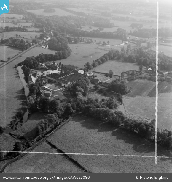
XAW027086 NORTHERN IRELAND (1949). Gallaher Ltd., Virginia House E.C. , Galgorm, Ballymena, Northern Ireland, 1949. Oblique aerial photograph taken facing South/East. This image was marked by Aerofilms Ltd for photo editing.
© Copyright OpenStreetMap contributors and licensed by the OpenStreetMap Foundation. 2025. Cartography is licensed as CC BY-SA.
Nearby Images (10)
Details
| Title | [XAW027086] Gallaher Ltd., Virginia House E.C. , Galgorm, Ballymena, Northern Ireland, 1949. Oblique aerial photograph taken facing South/East. This image was marked by Aerofilms Ltd for photo editing. |
| Reference | XAW027086 |
| Date | 4-October-1949 |
| Link | |
| Place name | GALGORM |
| Parish | NORTHERN IRELAND |
| District | |
| Country | NORTHERN IRELAND |
| Easting / Northing | 122141, 560308 |
| Longitude / Latitude | -6.33142, 54.860177 |
| National Grid Reference |
Pins
Be the first to add a comment to this image!


![[XAW027086] Gallaher Ltd., Virginia House E.C. , Galgorm, Ballymena, Northern Ireland, 1949. Oblique aerial photograph taken facing South/East. This image was marked by Aerofilms Ltd for photo editing.](http://britainfromabove.org.uk/sites/all/libraries/aerofilms-images/public/100x100/XAW/027/XAW027086.jpg)
![[XAW027091] Gallaher Ltd., Virginia House E.C. , Galgorm, Ballymena, Northern Ireland, 1949. Oblique aerial photograph taken facing North/East.](http://britainfromabove.org.uk/sites/all/libraries/aerofilms-images/public/100x100/XAW/027/XAW027091.jpg)
![[XAW027092] Gallaher Ltd., Virginia House E.C. , Galgorm, Ballymena, Northern Ireland, 1949. Oblique aerial photograph taken facing West.](http://britainfromabove.org.uk/sites/all/libraries/aerofilms-images/public/100x100/XAW/027/XAW027092.jpg)
![[XAW027093] Gallaher Ltd., Virginia House E.C. , Galgorm, Ballymena, Northern Ireland, 1949. Oblique aerial photograph taken facing South/East.](http://britainfromabove.org.uk/sites/all/libraries/aerofilms-images/public/100x100/XAW/027/XAW027093.jpg)
![[XAW027087] Gallaher Ltd., Virginia House E.C. , Galgorm, Ballymena, Northern Ireland, 1949. Oblique aerial photograph taken facing South/East. This image was marked by Aerofilms Ltd for photo editing.](http://britainfromabove.org.uk/sites/all/libraries/aerofilms-images/public/100x100/XAW/027/XAW027087.jpg)
![[XAW027089] Gallaher Ltd., Virginia House E.C. , Galgorm, Ballymena, Northern Ireland, 1949. Oblique aerial photograph taken facing East.](http://britainfromabove.org.uk/sites/all/libraries/aerofilms-images/public/100x100/XAW/027/XAW027089.jpg)
![[XAW027085] Gallaher Ltd., Virginia House E.C. , Galgorm, Ballymena, Northern Ireland, 1949. Oblique aerial photograph taken facing North/West. This image was marked by Aerofilms Ltd for photo editing.](http://britainfromabove.org.uk/sites/all/libraries/aerofilms-images/public/100x100/XAW/027/XAW027085.jpg)
![[XAW027088] Gallaher Ltd., Virginia House E.C. , Galgorm, Ballymena, Northern Ireland, 1949. Oblique aerial photograph taken facing North/East.](http://britainfromabove.org.uk/sites/all/libraries/aerofilms-images/public/100x100/XAW/027/XAW027088.jpg)
![[XAW027090] Gallaher Ltd., Virginia House E.C. , Galgorm, Ballymena, Northern Ireland, 1949. Oblique aerial photograph taken facing West.](http://britainfromabove.org.uk/sites/all/libraries/aerofilms-images/public/100x100/XAW/027/XAW027090.jpg)
![[XAW027094] Gallaher Ltd., Virginia House E.C. , Galgorm, Ballymena, Northern Ireland, 1949. Oblique aerial photograph taken facing West.](http://britainfromabove.org.uk/sites/all/libraries/aerofilms-images/public/100x100/XAW/027/XAW027094.jpg)