
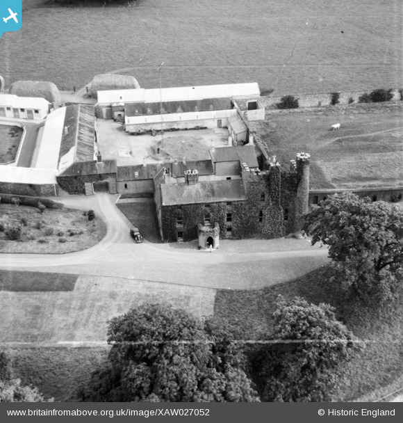
XAW027052 IRELAND (1949). Turvey House, Donabate, Dublin, Ireland, 1949. Oblique aerial photograph taken facing East. This image was marked by Aerofilms Ltd for photo editing.
© Copyright OpenStreetMap contributors and licensed by the OpenStreetMap Foundation. 2025. Cartography is licensed as CC BY-SA.
Nearby Images (6)
XAW027052

XAW027048

XAW027051

XAW027049

XAW027050

XAW027047

Details
| Title | [XAW027052] Turvey House, Donabate, Dublin, Ireland, 1949. Oblique aerial photograph taken facing East. This image was marked by Aerofilms Ltd for photo editing. |
| Reference | XAW027052 |
| Date | 1949 |
| Link | |
| Place name | DONABATE |
| Parish | IRELAND |
| District | |
| Country | IRELAND |
| Easting / Northing | 122904, 406623 |
| Longitude / Latitude | -6.178135, 53.483169 |
| National Grid Reference |
Pins
 |

waiguoren |
Sunday 30th of July 2023 11:39:36 AM |
 |
waiguoren |
Sunday 30th of July 2023 11:03:52 AM |
User Comment Contributions
This is not Turvey House David J Griffin Dublin |
David J Griffin |
Tuesday 5th of April 2016 12:56:38 PM |
This is not Turvey House. David J Griffin Dublin |
David J Griffin |
Tuesday 5th of April 2016 12:54:43 PM |
Anyone know where this is? It is labelled as Turvey House, Donabate but appears to be very different to this photo (which I'm sure is of Turvey House, Donabate) http://www.britainfromabove.org.uk/image/xaw019351?search=donabate&ref=0 |
waiguoren |
Monday 23rd of March 2015 01:56:28 PM |