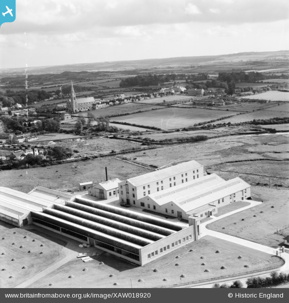
XAW018920 IRELAND (1948). The Midleton Worsted Mills, Midleton, Cork, Ireland, 1948. Oblique aerial photograph taken facing South/East. This image was marked by Aerofilms Ltd for photo editing.
© Copyright OpenStreetMap contributors and licensed by the OpenStreetMap Foundation. 2026. Cartography is licensed as CC BY-SA.
Nearby Images (12)
Details
| Title | [XAW018920] The Midleton Worsted Mills, Midleton, Cork, Ireland, 1948. Oblique aerial photograph taken facing South/East. This image was marked by Aerofilms Ltd for photo editing. |
| Reference | XAW018920 |
| Date | 24-September-1948 |
| Link | |
| Place name | MIDLETON |
| Parish | IRELAND |
| District | |
| Country | IRELAND |
| Easting / Northing | -24642, 241754 |
| Longitude / Latitude | -8.177517, 51.911843 |
| National Grid Reference |
Pins

powerpop |
Saturday 2nd of May 2015 05:41:16 PM |


![[XAW018920] The Midleton Worsted Mills, Midleton, Cork, Ireland, 1948. Oblique aerial photograph taken facing South/East. This image was marked by Aerofilms Ltd for photo editing.](http://britainfromabove.org.uk/sites/all/libraries/aerofilms-images/public/100x100/XAW/018/XAW018920.jpg)
![[XAW018931] The Midleton Worsted Mills, Midleton, Cork, Ireland, 1948. Oblique aerial photograph taken facing North/East.](http://britainfromabove.org.uk/sites/all/libraries/aerofilms-images/public/100x100/XAW/018/XAW018931.jpg)
![[XAW018918] The Midleton Worsted Mills, Midleton, Cork, Ireland, 1948. Oblique aerial photograph taken facing South/East.](http://britainfromabove.org.uk/sites/all/libraries/aerofilms-images/public/100x100/XAW/018/XAW018918.jpg)
![[XAW018923] The Midleton Worsted Mills, Main Building, Midleton, Cork, Ireland, 1948. Oblique aerial photograph taken facing East.](http://britainfromabove.org.uk/sites/all/libraries/aerofilms-images/public/100x100/XAW/018/XAW018923.jpg)
![[XAW018924] The Midleton Worsted Mills, Main Building, Midleton, Cork, Ireland, 1948. Oblique aerial photograph taken facing South.](http://britainfromabove.org.uk/sites/all/libraries/aerofilms-images/public/100x100/XAW/018/XAW018924.jpg)
![[XAW018922] The Midleton Worsted Mills, Midleton, Cork, Ireland, 1948. Oblique aerial photograph taken facing North/East. This image was marked by Aerofilms Ltd for photo editing.](http://britainfromabove.org.uk/sites/all/libraries/aerofilms-images/public/100x100/XAW/018/XAW018922.jpg)
![[XAW018925] The Midleton Worsted Mills, Main Building, Midleton, Cork, Ireland, 1948. Oblique aerial photograph taken facing East.](http://britainfromabove.org.uk/sites/all/libraries/aerofilms-images/public/100x100/XAW/018/XAW018925.jpg)
![[XAW018919] The Midleton Worsted Mills, Midleton, Cork, Ireland, 1948. Oblique aerial photograph taken facing North. This image was marked by Aerofilms Ltd for photo editing.](http://britainfromabove.org.uk/sites/all/libraries/aerofilms-images/public/100x100/XAW/018/XAW018919.jpg)
![[XAW018921] The Midleton Worsted Mills, Midleton, Cork, Ireland, 1948. Oblique aerial photograph taken facing North/East. This image was marked by Aerofilms Ltd for photo editing.](http://britainfromabove.org.uk/sites/all/libraries/aerofilms-images/public/100x100/XAW/018/XAW018921.jpg)
![[XAW018930] The Midleton Worsted Mills, Midleton, Cork, Ireland, 1948. Oblique aerial photograph taken facing North/West. This image was marked by Aerofilms Ltd for photo editing.](http://britainfromabove.org.uk/sites/all/libraries/aerofilms-images/public/100x100/XAW/018/XAW018930.jpg)
![[XAW018926] The Midleton Worsted Mills, Midleton, Cork, Ireland, 1948. Oblique aerial photograph taken facing South. This image was marked by Aerofilms Ltd for photo editing.](http://britainfromabove.org.uk/sites/all/libraries/aerofilms-images/public/100x100/XAW/018/XAW018926.jpg)
![[XPW042390] General View, Midleton, Cork, Ireland, 1933. Oblique aerial photograph taken facing South.](http://britainfromabove.org.uk/sites/all/libraries/aerofilms-images/public/100x100/XPW/042/XPW042390.jpg)