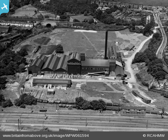
WPW061594 WALES (1939). View of Pilkington Brothers Ltd., Pontypool Works, oblique aerial view. 5"x4" black and white glass plate negative.
© Copyright OpenStreetMap contributors and licensed by the OpenStreetMap Foundation. 2026. Cartography is licensed as CC BY-SA.
Details
| Title | [WPW061594] View of Pilkington Brothers Ltd., Pontypool Works, oblique aerial view. 5"x4" black and white glass plate negative. |
| Reference | WPW061594 |
| Date | 1939 |
| Link | Coflein Archive Item 6370507 |
| Place name | |
| Parish | |
| District | |
| Country | WALES |
| Easting / Northing | 329588, 200152 |
| Longitude / Latitude | -3.0188648732363, 51.695234734498 |
| National Grid Reference | SO296002 |
Pins

Rudolf Hucker |
Sunday 17th of February 2019 04:00:16 PM | |

Rudolf Hucker |
Sunday 17th of February 2019 03:57:59 PM | |

John W |
Sunday 19th of March 2017 06:14:28 PM | |

Bloodthorn |
Sunday 19th of May 2013 06:13:00 PM | |

Bloodthorn |
Sunday 19th of May 2013 06:11:37 PM | |

Bloodthorn |
Sunday 19th of May 2013 06:10:45 PM | |

Bloodthorn |
Wednesday 27th of June 2012 11:12:25 PM | |

Bloodthorn |
Wednesday 27th of June 2012 11:11:09 PM | |

Bloodthorn |
Wednesday 27th of June 2012 11:10:38 PM | |

Bloodthorn |
Wednesday 27th of June 2012 11:10:14 PM | |

Bloodthorn |
Wednesday 27th of June 2012 11:09:49 PM | |

Bloodthorn |
Wednesday 27th of June 2012 11:09:23 PM |


![[WPW061594] View of Pilkington Brothers Ltd., Pontypool Works, oblique aerial view. 5"x4" black and white glass plate negative.](http://britainfromabove.org.uk/sites/all/libraries/aerofilms-images/public/100x100/WPW/061/WPW061594.jpg)
![[WPW061595] View of Pilkington Brothers Ltd., Pontypool Works, oblique aerial view. 5"x4" black and white glass plate negative.](http://britainfromabove.org.uk/sites/all/libraries/aerofilms-images/public/100x100/WPW/061/WPW061595.jpg)
![[WPW061597] View of Pilkington Brothers Ltd., Pontypool Works, oblique aerial view. 5"x4" black and white glass plate negative.](http://britainfromabove.org.uk/sites/all/libraries/aerofilms-images/public/100x100/WPW/061/WPW061597.jpg)
![[WPW061598] View of Pilkington Brothers Ltd., Pontypool Works, oblique aerial view. 5"x4" black and white glass plate negative.](http://britainfromabove.org.uk/sites/all/libraries/aerofilms-images/public/100x100/WPW/061/WPW061598.jpg)
![[WPW061599] View of Pilkington Brothers Ltd., Pontypool Works, oblique aerial view. 5"x4" black and white glass plate negative.](http://britainfromabove.org.uk/sites/all/libraries/aerofilms-images/public/100x100/WPW/061/WPW061599.jpg)