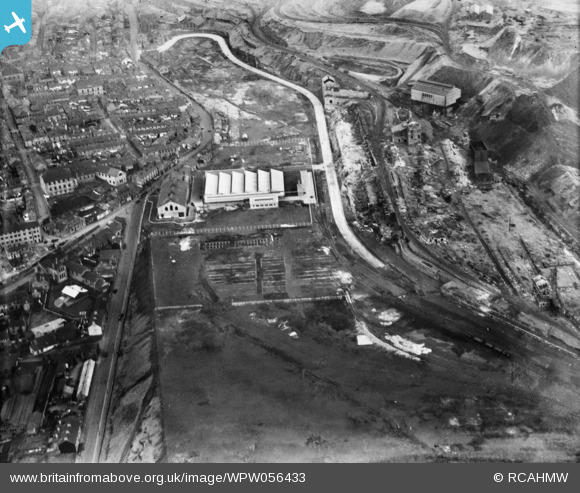
WPW056433 WALES (1938). View of Dowlais Ironworks showing Dowlais great tip, oblique aerial view. 5"x4" black and white glass plate negative.
© Copyright OpenStreetMap contributors and licensed by the OpenStreetMap Foundation. 2026. Cartography is licensed as CC BY-SA.
Nearby Images (16)
Details
| Title | [WPW056433] View of Dowlais Ironworks showing Dowlais great tip, oblique aerial view. 5"x4" black and white glass plate negative. |
| Reference | WPW056433 |
| Date | 1938 |
| Link | Coflein Archive Item 6370435 |
| Place name | |
| Parish | |
| District | |
| Country | WALES |
| Easting / Northing | 307120, 207630 |
| Longitude / Latitude | -3.3458882294667, 51.759190866247 |
| National Grid Reference | SO071076 |


![[WPW029862] View of Guest, Keen & Nettlefold, Dowlais Works, Merthyr Tydfil, oblique aerial view. 5"x4" black and white glass plate negative.](http://britainfromabove.org.uk/sites/all/libraries/aerofilms-images/public/100x100/WPW/029/WPW029862.jpg)
![[WPW029864] View of Guest, Keen & Nettlefold - Dowlais Ironworks, Merthyr Tydfil. Oblique aerial photograph, 5"x4" BW glass plate.](http://britainfromabove.org.uk/sites/all/libraries/aerofilms-images/public/100x100/WPW/029/WPW029864.jpg)
![[WPW029867] View of Dowlais Ironworks, Merthyr showing the 'Goat Mill'. Oblique aerial photograph, 5"x4" BW glass plate.](http://britainfromabove.org.uk/sites/all/libraries/aerofilms-images/public/100x100/WPW/029/WPW029867.jpg)
![[WPW029871] View of Dowlais Ironworks, Merthyr showing the 'Goat Mill'. Oblique aerial photograph, 5"x4" BW glass plate.](http://britainfromabove.org.uk/sites/all/libraries/aerofilms-images/public/100x100/WPW/029/WPW029871.jpg)
![[WPW029872] View of Guest, Keen & Nettlefold, Dowlais Works, Merthyr Tydfil, oblique aerial view. 5"x4" black and white glass plate negative.](http://britainfromabove.org.uk/sites/all/libraries/aerofilms-images/public/100x100/WPW/029/WPW029872.jpg)
![[WPW029874] View of Guest, Keen & Nettlefold, Dowlais Works, Merthyr Tydfil, oblique aerial view. 5"x4" black and white glass plate negative.](http://britainfromabove.org.uk/sites/all/libraries/aerofilms-images/public/100x100/WPW/029/WPW029874.jpg)
![[WPW029875] View of Guest, Keen & Nettlefold, Dowlais Works, Merthyr Tydfil, oblique aerial view. 5"x4" black and white glass plate negative.](http://britainfromabove.org.uk/sites/all/libraries/aerofilms-images/public/100x100/WPW/029/WPW029875.jpg)
![[WPW029879] View of Guest, Keen & Nettlefold, Dowlais Works, Merthyr Tydfil, oblique aerial view. 5"x4" black and white glass plate negative.](http://britainfromabove.org.uk/sites/all/libraries/aerofilms-images/public/100x100/WPW/029/WPW029879.jpg)
![[WPW056427] View of Dowlais Ironworks showing Dowlais great tip, oblique aerial view. 5"x4" black and white glass plate negative.](http://britainfromabove.org.uk/sites/all/libraries/aerofilms-images/public/100x100/WPW/056/WPW056427.jpg)
![[WPW056428] View of Dowlais Ironworks showing Dowlais great tip, oblique aerial view. 5"x4" black and white glass plate negative.](http://britainfromabove.org.uk/sites/all/libraries/aerofilms-images/public/100x100/WPW/056/WPW056428.jpg)
![[WPW056429] View of Dowlais Ironworks showing Dowlais great tip, oblique aerial view. 5"x4" black and white glass plate negative.](http://britainfromabove.org.uk/sites/all/libraries/aerofilms-images/public/100x100/WPW/056/WPW056429.jpg)
![[WPW056430] View of Dowlais Ironworks showing Dowlais great tip, oblique aerial view. 5"x4" black and white glass plate negative.](http://britainfromabove.org.uk/sites/all/libraries/aerofilms-images/public/100x100/WPW/056/WPW056430.jpg)
![[WPW056431] View of Dowlais Ironworks showing Dowlais great tip, oblique aerial view. 5"x4" black and white glass plate negative.](http://britainfromabove.org.uk/sites/all/libraries/aerofilms-images/public/100x100/WPW/056/WPW056431.jpg)
![[WPW056432] View of Dowlais Ironworks showing Dowlais great tip, oblique aerial view. 5"x4" black and white glass plate negative.](http://britainfromabove.org.uk/sites/all/libraries/aerofilms-images/public/100x100/WPW/056/WPW056432.jpg)
![[WPW056433] View of Dowlais Ironworks showing Dowlais great tip, oblique aerial view. 5"x4" black and white glass plate negative.](http://britainfromabove.org.uk/sites/all/libraries/aerofilms-images/public/100x100/WPW/056/WPW056433.jpg)
![[WPW056434] View of Dowlais Ironworks showing Dowlais great tip, oblique aerial view. 5"x4" black and white glass plate negative.](http://britainfromabove.org.uk/sites/all/libraries/aerofilms-images/public/100x100/WPW/056/WPW056434.jpg)
