
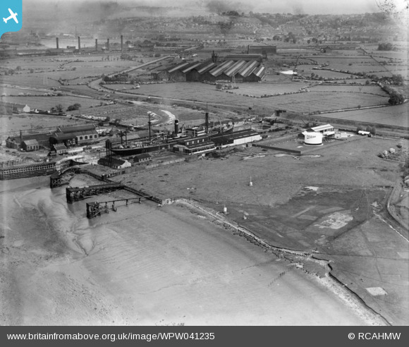
WPW041235 WALES (1933). View of Union Dry Docks, Newport, oblique aerial view. 5"x4" black and white glass plate negative.
© Copyright OpenStreetMap contributors and licensed by the OpenStreetMap Foundation. 2025. Cartography is licensed as CC BY-SA.
Nearby Images (12)
WPW034828

WPW034829

WPW034830

WPW034831

WPW034832

WPW034833

WPW034834

WPW034835

WPW034836

WPW034837

WPW041235

WPW041236

Details
| Title | [WPW041235] View of Union Dry Docks, Newport, oblique aerial view. 5"x4" black and white glass plate negative. |
| Reference | WPW041235 |
| Date | 1933 |
| Link | Coflein Archive Item 6369733 |
| Place name | |
| Parish | |
| District | |
| Country | WALES |
| Easting / Northing | 333020, 185270 |
| Longitude / Latitude | -2.9663641439452, 51.561850432715 |
| National Grid Reference | ST330853 |
Pins
Be the first to add a comment to this image!
User Comment Contributions
That's the lower end of Corporation Road curving away northwards in the background. On the right the clerestoried sheds are/were (?) the Orb Tube works and the five chimneys further off served the Orb Steel Works. From Google Earth it appears that today the Union Dock trades in sand or gavel and possibly imports coal too! Sic transit gloria... |
 czyrko |
Friday 27th of December 2013 06:44:32 PM |
East Usk Dry Docks later Bell Port |
Louis |
Saturday 19th of January 2013 04:00:33 PM |