
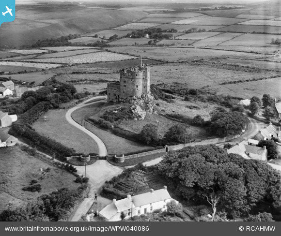
WPW040086 WALES (1932). View of Roch Castle and Castle Farm, Roch, Pembrokeshire, oblique aerial view. 5"x4" black and white glass plate negative.
© Copyright OpenStreetMap contributors and licensed by the OpenStreetMap Foundation. 2026. Cartography is licensed as CC BY-SA.
Nearby Images (3)
WPW040086

WPW040087

WPW040088

Details
| Title | [WPW040086] View of Roch Castle and Castle Farm, Roch, Pembrokeshire, oblique aerial view. 5"x4" black and white glass plate negative. |
| Reference | WPW040086 |
| Date | 1932 |
| Link | Coflein Archive Item 6378306 |
| Place name | |
| Parish | |
| District | |
| Country | WALES |
| Easting / Northing | 188040, 221140 |
| Longitude / Latitude | -5.0777626035078, 51.848105727251 |
| National Grid Reference | SM880211 |
Pins

totoro |
Saturday 18th of January 2014 10:20:00 PM | |
|
totoro |
Saturday 18th of January 2014 10:05:12 PM | |

Maurice |
Thursday 18th of April 2013 05:06:30 PM | |
|
DeborahWales |
Thursday 18th of April 2013 10:27:58 AM | |
the Church of St Mary: Constructed between 1857-1865 on the site of a far more ancient place of worship Grade 2 listed building - Cadw Building ID: 19080 CADW do not list details of Welsh listed buildings on the internet. Nearby the church was a butter and fish market. |
totoro |
Saturday 18th of January 2014 10:03:18 PM |
|
DeborahWales |
Thursday 18th of April 2013 10:26:20 AM | |
|
DeborahWales |
Thursday 18th of April 2013 10:25:48 AM | |
|
DeborahWales |
Thursday 18th of April 2013 10:25:15 AM | |
|
DeborahWales |
Thursday 18th of April 2013 10:24:44 AM |
User Comment Contributions

Before and after reconstruction- images from http://www.celticcastles.com/ (photographer uncredited on the site) |
totoro |
Saturday 18th of January 2014 10:16:30 PM |
When looking at the aerial pictures in 2013 it is surprising just how building, both housing and agricultural has changed the scene around this image. It has become a little piece of urbanisation of the countryside, especially to the left (west) of the picture. Nature has also changed the scene, with rather more tree cover present within the castle walls. This is also a noticeable feature of many of the rural pictures ... the increase in the number of trees. |
Maurice |
Friday 19th of April 2013 07:25:17 AM |
The cottage in the foreground became the Old Post Office and is now a private home. Manor Farm is just to the right where some buildings are just visible. North Gate Farm is just visible in the upper left corner of the photograph |
DeborahWales |
Thursday 18th of April 2013 10:21:10 AM |