
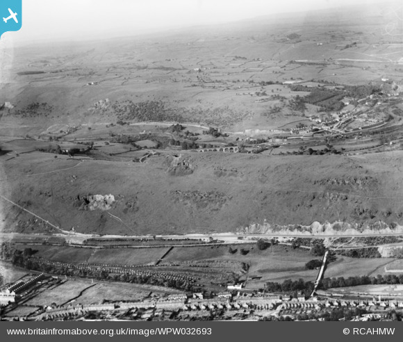
WPW032693 WALES (1930). General view of Ynysboeth and Pont Cynon, oblique aerial view. 5"x4" black and white glass plate negative.
© Copyright OpenStreetMap contributors and licensed by the OpenStreetMap Foundation. 2026. Cartography is licensed as CC BY-SA.
Nearby Images (8)
WAW005810

WAW005811

WAW005812

WAW005813

WAW005814

WAW005815

WAW005816

WPW032693

Details
| Title | [WPW032693] General view of Ynysboeth and Pont Cynon, oblique aerial view. 5"x4" black and white glass plate negative. |
| Reference | WPW032693 |
| Date | 1930 |
| Link | Coflein Archive Item 6370845 |
| Place name | |
| Parish | |
| District | |
| Country | WALES |
| Easting / Northing | 307270, 196120 |
| Longitude / Latitude | -3.3406526295305, 51.655744063496 |
| National Grid Reference | ST073961 |
Pins

gBr |
Thursday 9th of March 2017 05:24:14 PM | |

Class31 |
Friday 21st of December 2012 02:59:12 PM | |
|
Class31 |
Friday 21st of December 2012 02:58:04 PM | |
|
Class31 |
Friday 21st of December 2012 02:51:35 PM | |
|
Class31 |
Friday 21st of December 2012 02:49:09 PM | |
|
Class31 |
Friday 21st of December 2012 02:47:51 PM | |
|
Class31 |
Friday 21st of December 2012 02:46:08 PM | |
|
Class31 |
Friday 21st of December 2012 02:41:45 PM | |
|
Class31 |
Friday 21st of December 2012 02:39:19 PM | |
|
Class31 |
Friday 21st of December 2012 02:34:21 PM | |
|
Class31 |
Friday 21st of December 2012 02:21:37 PM | |
|
Class31 |
Friday 21st of December 2012 02:19:24 PM |
User Comment Contributions
Dear Class31, thank you for your extremely helpful comments, we have looked at your suggestions and agree with you, Ynysboeth and Pont Cynon are far more relevant labels for this image. we have since amended the description to better suit the content. Thank you again for your continued enthusiasm with the project. Natasha Scullion Britain from Above Activity Officer |
Natasha Scullion |
Monday 19th of November 2012 11:16:42 AM |
The bottom of the photo is at Map Reference ST 07479 95878 |
Class31 |
Tuesday 17th of July 2012 12:48:57 PM |
This image is about seven miles South of the map reference given. It does not show the town of Merthyr Tydfil but shows Ynysboeth and Pont Cynon in the foreground which are now in Rhondda, Cynon, Taff administrative area. The community in the middle distance is Edwardsville which is in the Merthyr Tydfil administrative area. |
Class31 |
Wednesday 27th of June 2012 02:15:18 PM |
It is misleading to describe this image as a general view of Merthyr Tydfil. The NGR given appears to be a gereric one given for a number of photos of the Merthyr area and is in fact a map reference for The Grove in Merthyr Tydfil which is about seven miles North of the centre of this image. |
Class31 |
Wednesday 27th of June 2012 02:10:28 PM |
In the foreground we see Pont Cynon and Ynysboeth. The other side of the Cynon Valley shows the road which is now the A4059. Over the ridge we are in the Taff Valley with the prominent Quakers Yard viaduct of the Great Western Railway and Rhymney Railway Joint Railway from Quakers Yard to Merthyr Tydfil. Quaker's Yard Station is to the right of the viaduct serving Edwardsville. In the distance the views are towards Cwm Bargoed. |
Class31 |
Wednesday 27th of June 2012 01:58:11 PM |