© Copyright OpenStreetMap contributors and licensed by the OpenStreetMap Foundation. 2024. Cartography is licensed as CC BY-SA.
Details
| Title |
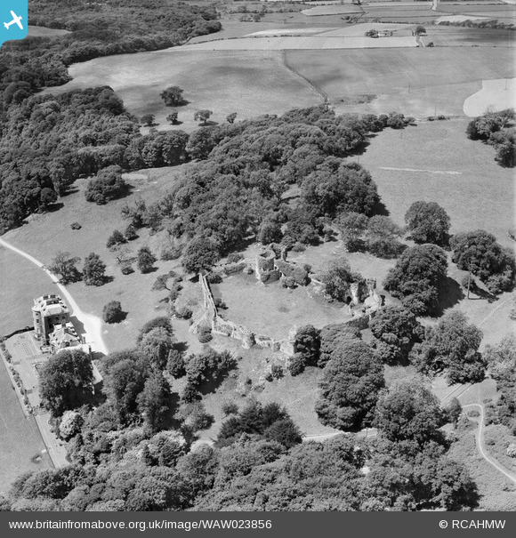
[WAW023856] View of Penrice castle also showing mansion |
| Reference |
WAW023856 |
| Date |
1949 |
| Link |
Coflein Archive Item 6414053 |
| Place name |
|
| Parish |
|
| District |
|
| Country |
WALES |
| Easting / Northing |
249710, 188500 |
| Longitude / Latitude |
-4.1690435667286, 51.574829497892 |
| National Grid Reference |
SS497885 |
Pins
  Penrice Castle Estate
The Estate came into the family’s ownership after the Norman conquest of the Gower peninsular in the twelfth century. One of the Norman knights was given the land around what is now Penrice village for his part in the conquest and took the name of de Penrice. Although the Estate has passed by marriage several times and suffered a partial break up in the 1950s, the core of the land around Penrice Castle and the village has remained in the family ever since - for twenty nine generations.
In the mid eighteenth century, however, the male line failed and the Penrice Estate passed by marriage to the Talbot family of Laycock Abbey in Wiltshire. By the 1770s the Estates belonged to the young Thomas Mansel Talbot, newly returned from the Grand Tour. He decided to build himself a neo-classical villa
at Penrice and this was completed in the mid 1770s to the design of the architect Anthony Keck.
The pleasure gardens and orangery, as well as the folly gatehouse known as the Towers, were added in the 1790s. The terrace around the house was built by Thomas Talbot’s granddaughter, Emily Charlotte Talbot, in the 1890s.
The late Georgian and Victorian sections of the house were demolished in the 1960s to be replaced by a paved rose garden.
The Mansion is Grade 1 listed: Cadw Building ID: 11531
source: Thomas Methuen-Campbell at http://penricecastle.co.uk/penrice-estate-history
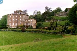
2002 image of mansion by Robert Edwards shows how much was demolished by comparing to the BFA images. Copyright Robert Edwards, licenced by Creative Commons Attribution Share-Alike licence.
Source: [[File:Penrice Castle, Gower, Sth. Wales - geograph.org.uk - 119951.jpg]] |

totoro |
Monday 6th of July 2015 10:19:38 PM |
  Penrice Castle (Castell Penrhys):
Penrice Castle is the 13th century successor to a strong ringwork to the southeast, known as the Mountybank. It was built by the de Penrice family who were originally given land at Penrice for their part in the Norman conquest of Gower. The last de Penrice married a Mansel in 1410 and so the castle and its lands passed to the Mansel family.
Penrice Castle is on private land, but a public footpath allows viewing of portions of the curtain and towers.
The castle ruins are Grade 2* listed as is the dovecote and various parts of the site (gates, railings, piers) are listed grade 2.
Ruins: Cadw Building ID: 11543
Probably much of the stonework remaining is C13; a window with seats in the north-west gatehouse overlooking the ward suggests the C13 and the gatehouse also has pointed arches. The castle was abandoned in favour of Oxwich Castle in the late mediaeval period and fell into ruin. It was slighted by Cromwell. When engraved by Buck in c1735 the surviving curtain wall still has its crenellations. The ruins were probably reduced for picturesque effect in the late C18.
Source: [[Penrice Castle]]
2011 image of castle by Alan Richards, copyright Alan Richards, licenced under Creative Commons Attribution Share Alike licence, source http://www.geograph.org.uk/photo/2440793 |

totoro |
Monday 6th of July 2015 10:16:49 PM |


![[WAW023854] View of Penrice castle also showing mansion](http://britainfromabove.org.uk/sites/all/libraries/aerofilms-images/public/100x100/WAW/023/WAW023854.jpg)
![[WAW023855] View of Penrice castle also showing mansion](http://britainfromabove.org.uk/sites/all/libraries/aerofilms-images/public/100x100/WAW/023/WAW023855.jpg)
![[WAW023856] View of Penrice castle also showing mansion](http://britainfromabove.org.uk/sites/all/libraries/aerofilms-images/public/100x100/WAW/023/WAW023856.jpg)
![[WAW033696] View of Penrice castle and mansion](http://britainfromabove.org.uk/sites/all/libraries/aerofilms-images/public/100x100/WAW/033/WAW033696.jpg)
![[WAW033697] View of Penrice castle and mansion](http://britainfromabove.org.uk/sites/all/libraries/aerofilms-images/public/100x100/WAW/033/WAW033697.jpg)

