
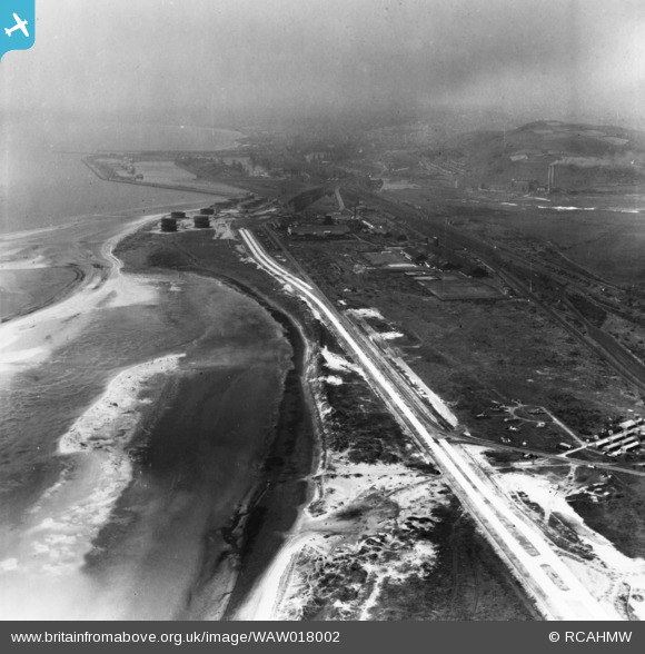
WAW018002 WALES (1948). View of Fabian Way, Swansea during construction. Oblique aerial photograph, 5½" cut roll film.
© Copyright OpenStreetMap contributors and licensed by the OpenStreetMap Foundation. 2026. Cartography is licensed as CC BY-SA.
Nearby Images (2)
WAW018001

WAW018002

Details
| Title | [WAW018002] View of Fabian Way, Swansea during construction. Oblique aerial photograph, 5½" cut roll film. |
| Reference | WAW018002 |
| Date | 10-August-1948 |
| Link | Coflein Archive Item 6423248 |
| Place name | |
| Parish | |
| District | |
| Country | WALES |
| Easting / Northing | 271630, 193360 |
| Longitude / Latitude | -3.8546580972204, 51.623928438423 |
| National Grid Reference | SS716934 |
Pins

Matt Aldred edob.mattaldred.com |
Monday 9th of June 2025 02:43:09 PM | |

Belorm |
Saturday 19th of September 2015 06:37:48 PM | |
|
Belorm |
Saturday 19th of September 2015 06:36:56 PM | |

Class31 |
Tuesday 6th of January 2015 10:47:47 AM | |
|
Class31 |
Tuesday 6th of January 2015 10:45:20 AM | |
|
Class31 |
Tuesday 6th of January 2015 10:43:14 AM | |
|
cptpies |
Monday 24th of November 2014 04:11:55 PM |
User Comment Contributions

Site of Tir John Power Station,14/11/2013 |
Class31 |
Tuesday 6th of January 2015 10:44:59 AM |

Site of Tir John Power Station,14/11/2013 |
Class31 |
Tuesday 6th of January 2015 10:44:27 AM |
Site of Tir John Power Station,14/11/2013 |
Class31 |
Tuesday 6th of January 2015 10:44:01 AM |

Aerial view taken from above Briton Ferry showing Baglan Bay, Swansea Docks and The Mumbles. We are looking south west. 9th October 2013. Courtesy Con Shields |
Class31 |
Tuesday 6th of January 2015 10:42:06 AM |

Aerial view of Swansea Docks and Baglan Bay looking south east, October 2013. Courtesy Con Shields |
Class31 |
Monday 5th of January 2015 09:17:28 AM |

Aerial view of King's Dock and Queen's Dock from the North, October 2013, Courtesy Con Shields |
Class31 |
Monday 5th of January 2015 08:11:13 AM |

HAA Battery nr fabian Way |
cptpies |
Monday 24th of November 2014 04:15:18 PM |