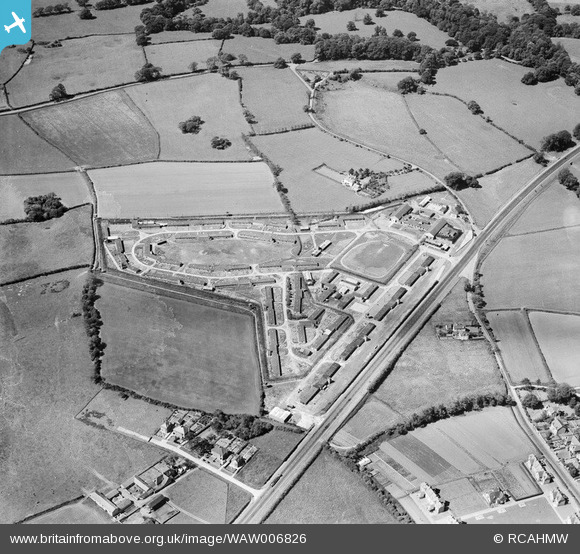
WAW006826 WALES (1947). View of Island Farm POW camp - the photograph was commissioned by the Gee, Walker & Slater construction company in 1947 for possible reuse as a development site for new housing.
© Copyright OpenStreetMap contributors and licensed by the OpenStreetMap Foundation. 2026. Cartography is licensed as CC BY-SA.
Nearby Images (9)
Details
| Title | [WAW006826] View of Island Farm POW camp - the photograph was commissioned by the Gee, Walker & Slater construction company in 1947 for possible reuse as a development site for new housing. |
| Reference | WAW006826 |
| Date | 1947 |
| Link | Coflein Archive Item 6413448 |
| Place name | |
| Parish | |
| District | |
| Country | WALES |
| Easting / Northing | 289900, 178400 |
| Longitude / Latitude | -3.5861301021583, 51.493325746036 |
| National Grid Reference | SS899784 |
Pins

MB |
Monday 19th of May 2014 03:35:12 PM |


![[WAW006819] View of Island Farm POW camp - the photograph was commissioned by the Gee, Walker & Slater construction company in 1947 for possible reuse as a development site for new housing.](http://britainfromabove.org.uk/sites/all/libraries/aerofilms-images/public/100x100/WAW/006/WAW006819.jpg)
![[WAW006820] View of Island Farm POW camp - the photograph was commissioned by the Gee, Walker & Slater construction company in 1947 for possible reuse as a development site for new housing.](http://britainfromabove.org.uk/sites/all/libraries/aerofilms-images/public/100x100/WAW/006/WAW006820.jpg)
![[WAW006821] View of Island Farm POW camp - the photograph was commissioned by the Gee, Walker & Slater construction company in 1947 for possible reuse as a development site for new housing.](http://britainfromabove.org.uk/sites/all/libraries/aerofilms-images/public/100x100/WAW/006/WAW006821.jpg)
![[WAW006822] View of Island Farm POW camp - the photograph was commissioned by the Gee, Walker & Slater construction company in 1947 for possible reuse as a development site for new housing.](http://britainfromabove.org.uk/sites/all/libraries/aerofilms-images/public/100x100/WAW/006/WAW006822.jpg)
![[WAW006823] View of Island Farm POW camp - the photograph was commissioned by the Gee, Walker & Slater construction company in 1947 for possible reuse as a development site for new housing.](http://britainfromabove.org.uk/sites/all/libraries/aerofilms-images/public/100x100/WAW/006/WAW006823.jpg)
![[WAW006824] View of Island Farm POW camp - the photograph was commissioned by the Gee, Walker & Slater construction company in 1947 for possible reuse as a development site for new housing.](http://britainfromabove.org.uk/sites/all/libraries/aerofilms-images/public/100x100/WAW/006/WAW006824.jpg)
![[WAW006825] View of Island Farm POW camp - the photograph was commissioned by the Gee, Walker & Slater construction company in 1947 for possible reuse as a development site for new housing.](http://britainfromabove.org.uk/sites/all/libraries/aerofilms-images/public/100x100/WAW/006/WAW006825.jpg)
![[WAW006826] View of Island Farm POW camp - the photograph was commissioned by the Gee, Walker & Slater construction company in 1947 for possible reuse as a development site for new housing.](http://britainfromabove.org.uk/sites/all/libraries/aerofilms-images/public/100x100/WAW/006/WAW006826.jpg)
![[WAW006827] View of Island Farm POW camp - the photograph was commissioned by the Gee, Walker & Slater construction company in 1947 for possible reuse as a development site for new housing.](http://britainfromabove.org.uk/sites/all/libraries/aerofilms-images/public/100x100/WAW/006/WAW006827.jpg)