
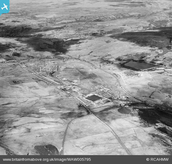
WAW005795 WALES (1947). Wide view of Hirwaen Royal Ordnance Factory
© Copyright OpenStreetMap contributors and licensed by the OpenStreetMap Foundation. 2026. Cartography is licensed as CC BY-SA.
Nearby Images (8)
WAW005790

WAW005791

WAW005793

WAW005794

WAW005795

WAW005796

WAW005797

WAW005798

Details
| Title | [WAW005795] Wide view of Hirwaen Royal Ordnance Factory |
| Reference | WAW005795 |
| Date | 19-May-1947 |
| Link | Coflein Archive Item 6413329 |
| Place name | |
| Parish | |
| District | |
| Country | WALES |
| Easting / Northing | 293500, 206300 |
| Longitude / Latitude | -3.5427706647601, 51.744810800879 |
| National Grid Reference | SN935063 |
Pins

chenahusky |
Thursday 12th of January 2017 01:13:31 PM | |

Class31 |
Monday 3rd of August 2015 07:03:25 AM | |
|
daiham |
Tuesday 13th of May 2014 03:42:40 PM | |
|
daiham |
Tuesday 13th of May 2014 03:40:18 PM | |
|
CR |
Saturday 10th of May 2014 09:09:56 PM | |
|
CR |
Saturday 10th of May 2014 09:09:19 PM | |
|
CR |
Saturday 10th of May 2014 09:08:44 PM |

User Comment Contributions
More information about Rhigos can be found at http://www.rhigosmemories.org.uk/rhigosmemories2/index.htm |
Class31 |
Monday 3rd of August 2015 08:09:00 AM |
For the benefit of readers I would say that Hirwaen is not the usual spelling for this location. Hirwaun is the more common spelling. A local slang pronounciation which was often heard from the 1960.s onwards was "erwin" |
Class31 |
Monday 13th of April 2015 08:39:11 AM |