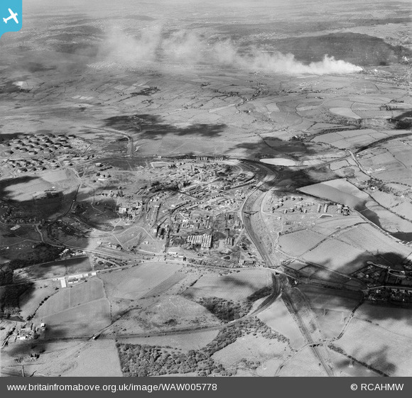
WAW005778 WALES (1947). View of Llandarcy Anglo Iranian oil refinery
© Copyright OpenStreetMap contributors and licensed by the OpenStreetMap Foundation. 2026. Cartography is licensed as CC BY-SA.
Nearby Images (48)
Details
| Title | [WAW005778] View of Llandarcy Anglo Iranian oil refinery |
| Reference | WAW005778 |
| Date | 19-May-1947 |
| Link | Coflein Archive Item 6413312 |
| Place name | |
| Parish | |
| District | |
| Country | WALES |
| Easting / Northing | 271000, 195500 |
| Longitude / Latitude | -3.8645437152259, 51.643017681742 |
| National Grid Reference | SS710955 |
Pins
Be the first to add a comment to this image!
User Comment Contributions

An aerial view of Llandarcy showing circular depressions where oil tanks have been removed, 9th October 2013. Courtesy Con Shields |

Class31 |
Saturday 1st of August 2015 09:42:23 AM |


![[WAW005772] View of Llandarcy Anglo Iranian oil refinery](http://britainfromabove.org.uk/sites/all/libraries/aerofilms-images/public/100x100/WAW/005/WAW005772.jpg)
![[WAW005773] View of Llandarcy Anglo Iranian oil refinery. A target for enemy bombers during World War 2, note the buildings still retain their wartime camouflage.](http://britainfromabove.org.uk/sites/all/libraries/aerofilms-images/public/100x100/WAW/005/WAW005773.jpg)
![[WAW005774] View of Llandarcy Anglo Iranian oil refinery. A target for enemy bombers during World War 2, note the buildings still retain their wartime camouflage.](http://britainfromabove.org.uk/sites/all/libraries/aerofilms-images/public/100x100/WAW/005/WAW005774.jpg)
![[WAW005776] View of Llandarcy Anglo Iranian oil refinery](http://britainfromabove.org.uk/sites/all/libraries/aerofilms-images/public/100x100/WAW/005/WAW005776.jpg)
![[WAW005777] View of Llandarcy Anglo Iranian oil refinery](http://britainfromabove.org.uk/sites/all/libraries/aerofilms-images/public/100x100/WAW/005/WAW005777.jpg)
![[WAW005778] View of Llandarcy Anglo Iranian oil refinery](http://britainfromabove.org.uk/sites/all/libraries/aerofilms-images/public/100x100/WAW/005/WAW005778.jpg)
![[WAW005779] View of Llandarcy Anglo Iranian oil refinery](http://britainfromabove.org.uk/sites/all/libraries/aerofilms-images/public/100x100/WAW/005/WAW005779.jpg)
![[WAW005780] View of Llandarcy Anglo Iranian oil refinery](http://britainfromabove.org.uk/sites/all/libraries/aerofilms-images/public/100x100/WAW/005/WAW005780.jpg)
![[WAW005781] View of Llandarcy Anglo Iranian oil refinery](http://britainfromabove.org.uk/sites/all/libraries/aerofilms-images/public/100x100/WAW/005/WAW005781.jpg)
![[WAW006989] View of Llandarcy Oil Refinery](http://britainfromabove.org.uk/sites/all/libraries/aerofilms-images/public/100x100/WAW/006/WAW006989.jpg)
![[WAW007000] View of Llandarcy Oil Refinery](http://britainfromabove.org.uk/sites/all/libraries/aerofilms-images/public/100x100/WAW/007/WAW007000.jpg)
![[WAW007001] View of Llandarcy Oil Refinery](http://britainfromabove.org.uk/sites/all/libraries/aerofilms-images/public/100x100/WAW/007/WAW007001.jpg)
![[WAW039160] View of Llandarcy Oil Refinery, commissioned by National Oil Refineries Ltd.](http://britainfromabove.org.uk/sites/all/libraries/aerofilms-images/public/100x100/WAW/039/WAW039160.jpg)
![[WAW039161] View of Llandarcy Oil Refinery, commissioned by National Oil Refineries Ltd.](http://britainfromabove.org.uk/sites/all/libraries/aerofilms-images/public/100x100/WAW/039/WAW039161.jpg)
![[WAW039162] View of Llandarcy Oil Refinery, commissioned by National Oil Refineries Ltd.](http://britainfromabove.org.uk/sites/all/libraries/aerofilms-images/public/100x100/WAW/039/WAW039162.jpg)
![[WAW039163] View of Llandarcy Oil Refinery, commissioned by National Oil Refineries Ltd.](http://britainfromabove.org.uk/sites/all/libraries/aerofilms-images/public/100x100/WAW/039/WAW039163.jpg)
![[WAW039164] View of Llandarcy Oil Refinery, commissioned by National Oil Refineries Ltd.](http://britainfromabove.org.uk/sites/all/libraries/aerofilms-images/public/100x100/WAW/039/WAW039164.jpg)
![[WAW039165] View of Llandarcy Oil Refinery, commissioned by National Oil Refineries Ltd.](http://britainfromabove.org.uk/sites/all/libraries/aerofilms-images/public/100x100/WAW/039/WAW039165.jpg)
![[WAW039166] View of Llandarcy Oil Refinery, commissioned by National Oil Refineries Ltd.](http://britainfromabove.org.uk/sites/all/libraries/aerofilms-images/public/100x100/WAW/039/WAW039166.jpg)
![[WAW039167] View of Llandarcy Oil Refinery, commissioned by National Oil Refineries Ltd.](http://britainfromabove.org.uk/sites/all/libraries/aerofilms-images/public/100x100/WAW/039/WAW039167.jpg)
![[WAW039168] View of Llandarcy Oil Refinery, commissioned by National Oil Refineries Ltd.](http://britainfromabove.org.uk/sites/all/libraries/aerofilms-images/public/100x100/WAW/039/WAW039168.jpg)
![[WAW039169] View of Llandarcy Oil Refinery, commissioned by National Oil Refineries Ltd.](http://britainfromabove.org.uk/sites/all/libraries/aerofilms-images/public/100x100/WAW/039/WAW039169.jpg)
![[WAW039170] View of Llandarcy Oil Refinery, commissioned by National Oil Refineries Ltd.](http://britainfromabove.org.uk/sites/all/libraries/aerofilms-images/public/100x100/WAW/039/WAW039170.jpg)
![[WAW039171] View of Llandarcy Oil Refinery, commissioned by National Oil Refineries Ltd.](http://britainfromabove.org.uk/sites/all/libraries/aerofilms-images/public/100x100/WAW/039/WAW039171.jpg)
![[WAW039172] View of Llandarcy Oil Refinery, commissioned by National Oil Refineries Ltd.](http://britainfromabove.org.uk/sites/all/libraries/aerofilms-images/public/100x100/WAW/039/WAW039172.jpg)
![[WAW039173] View of Llandarcy Oil Refinery, commissioned by National Oil Refineries Ltd.](http://britainfromabove.org.uk/sites/all/libraries/aerofilms-images/public/100x100/WAW/039/WAW039173.jpg)
![[WAW039174] View of Llandarcy Oil Refinery, commissioned by National Oil Refineries Ltd.](http://britainfromabove.org.uk/sites/all/libraries/aerofilms-images/public/100x100/WAW/039/WAW039174.jpg)
![[WAW039175] View of Llandarcy Oil Refinery, commissioned by National Oil Refineries Ltd.](http://britainfromabove.org.uk/sites/all/libraries/aerofilms-images/public/100x100/WAW/039/WAW039175.jpg)
![[WPW011954] View of Swansea Anglo Persian Oil Co. (Llandarcy Oil Refinery), oblique aerial view. 5"x4" black and white glass plate negative.](http://britainfromabove.org.uk/sites/all/libraries/aerofilms-images/public/100x100/WPW/011/WPW011954.jpg)
![[WPW029737] Llandarcy oil refinery, oblique aerial view. 5"x4" black and white glass plate negative.](http://britainfromabove.org.uk/sites/all/libraries/aerofilms-images/public/100x100/WPW/029/WPW029737.jpg)
![[WPW041415] View of Anglo-Persion Oil Depot, Llandarcy, oblique aerial view. 5"x4" black and white glass plate negative.](http://britainfromabove.org.uk/sites/all/libraries/aerofilms-images/public/100x100/WPW/041/WPW041415.jpg)
![[WPW041416] View of construction of Oil Refinery, Llandarcy, oblique aerial view. 5"x4" black and white glass plate negative.](http://britainfromabove.org.uk/sites/all/libraries/aerofilms-images/public/100x100/WPW/041/WPW041416.jpg)
![[WPW044821] View of National Oil Refineries (Anglo-Persion) Llandarcy, oblique aerial view. 5"x4" black and white glass plate negative.](http://britainfromabove.org.uk/sites/all/libraries/aerofilms-images/public/100x100/WPW/044/WPW044821.jpg)
![[WPW044822] View of National Oil Refineries (Anglo-Persion) Llandarcy, oblique aerial view. 5"x4" black and white glass plate negative.](http://britainfromabove.org.uk/sites/all/libraries/aerofilms-images/public/100x100/WPW/044/WPW044822.jpg)
![[WPW044823] View of National Oil Refineries (Anglo-Persion) Llandarcy, oblique aerial view. 5"x4" black and white glass plate negative.](http://britainfromabove.org.uk/sites/all/libraries/aerofilms-images/public/100x100/WPW/044/WPW044823.jpg)
![[WPW044824] View of National Oil Refineries (Anglo-Persion) Llandarcy, oblique aerial view. 5"x4" black and white glass plate negative.](http://britainfromabove.org.uk/sites/all/libraries/aerofilms-images/public/100x100/WPW/044/WPW044824.jpg)
![[WPW044825] View of National Oil Refineries (Anglo-Persion) Llandarcy, oblique aerial view. 5"x4" black and white glass plate negative.](http://britainfromabove.org.uk/sites/all/libraries/aerofilms-images/public/100x100/WPW/044/WPW044825.jpg)
![[WPW044826] View of National Oil Refineries (Anglo-Persion) Llandarcy, oblique aerial view. 5"x4" black and white glass plate negative.](http://britainfromabove.org.uk/sites/all/libraries/aerofilms-images/public/100x100/WPW/044/WPW044826.jpg)
![[WPW044827] View of National Oil Refineries (Anglo-Persion) Llandarcy, oblique aerial view. 5"x4" black and white glass plate negative.](http://britainfromabove.org.uk/sites/all/libraries/aerofilms-images/public/100x100/WPW/044/WPW044827.jpg)
![[WPW044828] View of National Oil Refineries (Anglo-Persion) Llandarcy, oblique aerial view. 5"x4" black and white glass plate negative.](http://britainfromabove.org.uk/sites/all/libraries/aerofilms-images/public/100x100/WPW/044/WPW044828.jpg)
![[WPW044829] View of National Oil Refineries (Anglo-Persion) Llandarcy, oblique aerial view. 5"x4" black and white glass plate negative.](http://britainfromabove.org.uk/sites/all/libraries/aerofilms-images/public/100x100/WPW/044/WPW044829.jpg)
![[WPW044830] View of National Oil Refineries (Anglo-Persion) Llandarcy, oblique aerial view. 5"x4" black and white glass plate negative.](http://britainfromabove.org.uk/sites/all/libraries/aerofilms-images/public/100x100/WPW/044/WPW044830.jpg)
![[WPW044831] View of National Oil Refineries (Anglo-Persion) Llandarcy, oblique aerial view. 5"x4" black and white glass plate negative.](http://britainfromabove.org.uk/sites/all/libraries/aerofilms-images/public/100x100/WPW/044/WPW044831.jpg)
![[WPW044832] View of National Oil Refineries (Anglo-Persion) Llandarcy, oblique aerial view. 5"x4" black and white glass plate negative.](http://britainfromabove.org.uk/sites/all/libraries/aerofilms-images/public/100x100/WPW/044/WPW044832.jpg)
![[WPW044833] View of National Oil Refineries (Anglo-Persion) Llandarcy, oblique aerial view. 5"x4" black and white glass plate negative.](http://britainfromabove.org.uk/sites/all/libraries/aerofilms-images/public/100x100/WPW/044/WPW044833.jpg)
![[WPW044834] View of National Oil Refineries (Anglo-Persion) Llandarcy, oblique aerial view. 5"x4" black and white glass plate negative.](http://britainfromabove.org.uk/sites/all/libraries/aerofilms-images/public/100x100/WPW/044/WPW044834.jpg)
![[WPW044835] View of National Oil Refineries (Anglo-Persion) Llandarcy, oblique aerial view. 5"x4" black and white glass plate negative.](http://britainfromabove.org.uk/sites/all/libraries/aerofilms-images/public/100x100/WPW/044/WPW044835.jpg)
![[WPW044836] View of National Oil Refineries (Anglo-Persion) Llandarcy, oblique aerial view. 5"x4" black and white glass plate negative.](http://britainfromabove.org.uk/sites/all/libraries/aerofilms-images/public/100x100/WPW/044/WPW044836.jpg)